Jacqueline and I spent Christmas in Michigan and Wisconsin once again. After a lot of presents, travelling, eating, and visiting, we set aside one day to get out on the trails. The problem was that there is not much for trails in the middle of Michigan where Jacqueline grew up. I searched around and finally found us some options. Since I wanted to see the Great Lakes, we headed for the closest one which was Lake Huron. We finally found Bay City State Park, which is not far from where Jacqueline grew up and a place that she had been before; the realization coming when we arrived. We headed out to check out the beach and the lake. It did not give us much land to use as a place to hike. I did not feel like I was in the pristine zone at all as we could see smoke stacks down the lake shore.  So we headed back into the car after taking the trail for a short mile long loop. We headed north from there to Tawas Point State Park. It was about an hour's drive from where we were, but the lake looked much different. There was a little point that we wanted to walk out to. We finally arrived and we took off toward the water.
  The wind was picking up a bit and it was definitely below freezing. We did get a decent hike out of this place. We started out hiking the beach, but we saw the trail above us, so we took that. Soon the trail turned into an old road, which headed straight out to the end of the point. Near the point, though, the trail took off back toward the parking lot. So we headed out to the point. When we got there, the end of the point was hard to tell as there were varying areas of water and beach. Jacqueline did not feel like walking across the ice, but I assured her it was safe, by even sliding across it.
  She had enough and we headed back through the screaming cold wind along the beach this time. We made it back to the car and it was a nice day. It made me appreciate where I live because I could get a good hike in from so many different places near where I live instead of having to search hard. We drove back in a snow storm and Jacqueline handled that with grace. She also handled the ski hills of Boyne Mountain with grace a couple days later as I struggled to stay upright. Jacqueline started skiing at five and she does not realize how much better that makes her than someone who is 22 until her dad and her were skiing like champs and I was trying not to run over eight year olds on the slopes.
It was a dark and stormy morning in Toquerville. The temperature was in the low 40s and it was misty outside. I was going through my email inbox trying to go through my old emails because hotmail is randomly deleting them on its own. I came across one from Brian Hays from years ago that said, "Climbing mountains is so awesome. I wish I was on a snowy, windy ridge right now." So I thought, yeah, me too. So I got my things together and I was out the door. I drove out to the closest thing I could find to a snowy, windy ridge, Toquerville Peak. I drove down a dirt road until the road looked too muddy and then just started walking. I was feeling pretty good on this day as I was just hauling. I studied my route on Google Earth the day before so I knew that I had to be patient. Southern Utah does not have much for well made trails, but they seem to have quite a few well made roads that no one drives on. This was one of those as I knew that it would go most of the way to the top considering there was a cell tower up there.
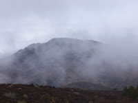 So I stayed patient as lots of roads split off, until finally I hit the one I thought that I wanted. It switched back a bit, but soon I was entering the mist. I could not tell how far I went, how long it was to go, or what could be around the next bend. I just kept following my road. Soon there was snow, which made it a bit more interesting. Then I saw the towers faintly through the fog and I knew I was close.
 From here I knew that the route to the summit was not too far away. (For a good pic of the summit, check my October blog for the highest point in the background.) Unfortunately, the road kept going except it was going straight up. The angle was rather steep and someone with an ATV decided that they were going to get to the top the easy way. That road went all the way to the summit ridge. All I had to do was traverse over a ways until I was at the true summit to chill out. The view was incredible.
 Actually it should have been, but there was nothing but mist. Toquerville peak is one of those peaks where if you were to climb its West Face, it would be highly technical. I should have been able to look down and see much of Southern Utah. Instead, all I saw was the fog.
 I snapped a couple pics and headed down, losing the trail/road in the fog for a while before finally
rediscovering it. When I got off the steep climb to the summit, the fog lifted for thirty seconds and I got a semi-decent view of the land below through the cell towers. Then I just wandered on back to my truck with nothing interesting happening except for the sighting of three deer. All and all, the trip took me a total of 3 hr 45 min round trip. It was a good hike, one that I would do again to maybe catch the views from the summit.
Neither Jacqueline or I had ever hiked in Snow Canyon before, so we thought that we would give it a shot. We were up bright and early before the Mormons were out of church, so we originally felt like we had the whole place to ourselves. We stopped first at the Lava Caves/White Rock Trailhead. We did not have a map so we just headed out on the trail. The first one ran right into some lava caves. We did not have a headlamp with us, so we did not make our attempt to go in. We continued on the trail, but it did not seem to go anywhere except down to a road. So we climbed up on some slickrock to hang out for a bit before continuing on another trail called the butterfly trail. We figured, that since it was December, we would not be seeing any butterflies on this trail, but we were mistaken. Jacqueline spotted one, probably near its last day of life since butterflies usually should not be out in December.
 Other than that, the butterfly trail did not have much to it until we ran into the road. So we decided to just head back to the truck leaving the White Rock trail to be done on another day. When I got back to my truck, I had a warning for me to pay my entrance fee. So I headed back up to the station and donated my $5 to Snow Canyon State Park. Next, we stopped at the Petrified Sand Dunes trail. I am not sure where it went, but since petrified sand dunes really just means rock, I figured we should just hike on the rock. Eventually, with some mediocre scrambling and bushwhacking, we ran into the Three Ponds trail. We took that one out to the Three Ponds. The trail was nothing more than an extremely sandy wash and the ponds were nothing more than potholes with seasonal run off stored within them. We snuck our way around the ponds to where we had the most scenic and interesting part of the day. There was some great slickrock walking with some excellent views.
 We ended our day about as far back as we felt like going. We probably could have kept scrambling from there, but since there was not much hidden, we called it a day right there. We headed back down to have our fun throwing rocks into the ponds. I snapped pictures of the ponds, but the pictures just looked like I took a picture of the rock.
 After giving Jacqueline a rock throwing lesson, we walked our way back until we ran into the Whiptail Trail, which we used to get back to our vehicle. The Whiptail is a paved trail which was not exciting but would be a nice short bike ride. We got back to our vehicle with about 3.5 hours of hiking under our belt. I would go back to Snow Canyon again, I would just gather some more info to see what are good off trail routes and how far those lava caves go.
My dad and I set out to backpack the whole Olympic National Park coast, 60-some miles. We had a three-tiered plan that included a three night backpack, then a one night backpack, and finishing with a day trip. We ignored all advice to not attempt this in the winter from various sources. It all started according to plan on Wednesday, when we drove up to Shi Shi Beach. It was pouring down rain. Shi Shi (pronounced shy-shy) is the northwest corner of Olympic National Park on the coast. There was a sign at the trailhead to not leave your car overnight, because it was near the res and there were a lot of break-ins. The sign on the stora ge building at the trailhead that said Gangsters Only was a good indicator also. So Laura dropped us off and we set out in the pouring rain. It was a two-mile or so hike through the forest and since the tides were going to be high on this day, we left in the late afternoon on purpose. We got to the ocean at around four o'clock and quickly had to find a place to camp. Our options were limited as darkness was rolling in, but we found a nice spot near a stream to camp. We spent the rest of the night trying to dry out in the foggy tent. Some cribbage and some book reading were good enough for the night's entertainment and we were able to get plenty of sleep in the soggy tent. We awoke the next day to clear skies. We did not have a long hike on this day, but we had to get going rather early in order to hit the tide when we wanted to.
 Our first obstacle to get around was Point of Arches. The picture is us approaching it (make sure to click on pictures to see them larger), but the point was rather long and rocky. I was learning, again, what a backpack on the ocean was all about. The beaches in the Northwest are not exactly sandy. They are for short period of time, but more often they are pebble size rocks to baseball size rocks, leading to a headwall with slippery bedrock that often is full of water, especially at high tide. That is why we were trying to move at low tide. Often there were bypass trails where you could climb up and around these headwalls, but those were journeys in themselves using old rope that most likely washed up on the beach to pull yourself up a slippery slope, especially a day after it had rained.
 That is what we had to do to make it around Point of Arches, which you possibly could see one of the many arches, if I was not blocking it by standing in the middle of the arch. There were a large series of headwalls on this day that we had to get around in a very short time period. I was enjoying my learning experience of figuring out which rocks to walk upon and which ones would make me fall over. Thus I was a bit slow and felt the pressure of the rising tide pushing me to go faster. Luckily, we had no major problems and were able to make it to the large long stretch of open beach before having to stop where the Ozette River dumped into the ocean.
 We knew it was going to be a problem, because my dad has been backpacking on the Pacific Ocean for 40 years. Thus, we had no choice but to chill out and wait for low tide. The problem with that was that it did not happen until 10pm and heck this was Northwest Washington in the winter. We tried our best to make a fire, but with no wind and some very wet wood, we seemed to get a lot of steam and smoke, but not much flame. So we chilled out in the tent and really were starting to chill. The temperature was dropping fast on this clear cold night. The thermometer in the tent read in the mid 30s when my dad came back from the beach at 9:20pm saying, there is a lot of beach, let's go for it. So we packed our stuff, grabbed our headlamps and sticks, and headed down the beach toward the river. We got a ways down and said, well this is as good of a place as any as we linked arms and attempted the river crossing. It went well, with the water only reaching up to around knee level. The river was so wide now and it took maybe four to five minutes to cross the entire stretch. Neither of us fell, which made us happy because we still had an hour walk to a campsite in the near freezing temperatures with soaking wet boots. It was not until 11:30pm when we were able to get to sleep at our campsite at Cape Alava. We still had to wake early as there were many places on this day where high tide could get us. Although it was very cold outside, it was also rather beautiful and sunny.
 We checked out some old petroglyphs near Cape Alava, which I was surprised that we could actually last in this wet climate. They were just on beach rocks
 instead of being on a beach wall. We did not spend too much time as we had to move in order to get through some of the points we would cross. There was some time to enjoy the world around us as we saw some seals or sea lions checking us out and we were also finding dead sea lions on the beach decomposing. Bald eagles were abundant, so we got to see them also. We passed Sand Point and Yellow Banks on this very wonderful day for backpacking at the ocean. Our stopping point on this day was Norwegian Memorial. We found a nice spot for the tent and spent the rest of the daylight on the beach.
 My dad tried to do some whale watching, but we were not lucky enough to see any whales on this trip. Instead we spent most of the evening on the beach and on this night, we were even able to have a successful fire to keep us warm and occupied. The night was so cold and I was glad to have my warm sleeping bag. When I awoke in the morning, I thought it felt a bit warmer which was strange. My dad, always the first one up, was able to let me know that it was starting to snow. That was going to be exciting. So we got an early start, where we were moving by seven-thirty. It was a good thing, because the weather was getting much worse. We had quite a few points to get across with a lot of slippery rocks, too. Where we went around, it was not much fun as I basically had to pull myself up a nearly vertical slope, hand over hand, with a rope. Then on the way back down,
 we had to use a ladder in order to descend the bank. This all would have been fun and games without a 40 pound pack on my back which makes everything more difficult. We made it fine and moved well past Cape Johnson and Chilean Memorial until we hit Hole-in-the-Wall where we knew we would be safe.
 All the while, the snow was increasing to where it was wet and cold. We also had the joy of having a California Sea Lion barking at us as we went along. We moved as fast we could, crossing Ellen Creek along the way until we popped out at Rialto Beach. Laura was supposed to meet us at 2pm, so we chilled out in the bathrooms, the only dry place, and there she was right at 2pm. after having some delays on the snowy highway. So we rode back to Forks, where we were able to check the weather. The next couple days looked brutal. We danced around it and finally decided to change plans. We headed out to Kalaloch the next day instead of La Push. We were trying to walk the whole coast, so our first trip was up north from Ruby Beach to boundary of the Hoh Reservation. That went well and the weather was not too bad yet. It was a bit windy and rainy, but nothing to be too concerned about. When we crossed the high flowing creek at Ruby Beach again, everything changed. The wind was just pounding in our faces now, making it hard to go forward at times. At the same time, the rain was driving very hard and just pounding against all the clothing meant to keep us dry. When we had to cross a point, the
 breaking waves were much higher than expected and we had to wade up above our knees. Soon everything was wet as each creek crossing kept our feet soaked and the driving rain kept everything cold and wet. After a while, I yelled to my dad that this is ridiculous. It was fun, but my fingers were throbbing they were so cold. So we decided to bail and go back to the road. That was not an easy process either, as we had to cross a flooding stream and fight through the salmonberry bushes before climbing a steep, muddy hill. It took about a half hour for someone to pick us up when we made it to the road in order to drop us off at Kalaloch. That was where we spent the rest of the weekend, because we had no choice. The wind whipped so hard that it took out trees and power lines in the process. Gusts were estimated up to 100 mph and sustained winds were in the forties and fifties easily.
 For us this meant that the waves were incredible. We were able to stand on the bank above and just watch the water pound against the beach. Washington beaches usually have quite a bit of driftwood, which is usually full large trees, sitting motionless above the high tide line. Well, on Monday, that driftwood became part of the active landscape. It was amazing to see whole trees just moved like small sticks by these huge waves.
 We did a couple of exploring missions, including a short beach walk at low tide. Mainly we just spent the time enjoying the storm, which was one of historic proportions. We also played quite a bit of cribbage and pinonchle, where I was much more successful at the former rather than the latter. On the following day, once the storm cleared, we went back to Ruby Beach and another beach to do some beach combing. While there was not much in the way of interesting beach finds, it was amazing to see the driftwood shoved back into where the live trees are, where driftwood would not usually be. We spent the rest of Tuesday making the long drive around, since roads were not open the other way. The trip did not turn out the way that we wanted to and it was disappointing to not get to hike the whole coast as we wanted, but it was definitely a trip to remember.
 So we headed back into the car after taking the trail for a short mile long loop. We headed north from there to Tawas Point State Park. It was about an hour's drive from where we were, but the lake looked much different. There was a little point that we wanted to walk out to. We finally arrived and we took off toward the water.
  The wind was picking up a bit and it was definitely below freezing. We did get a decent hike out of this place. We started out hiking the beach, but we saw the trail above us, so we took that. Soon the trail turned into an old road, which headed straight out to the end of the point. Near the point, though, the trail took off back toward the parking lot. So we headed out to the point. When we got there, the end of the point was hard to tell as there were varying areas of water and beach. Jacqueline did not feel like walking across the ice, but I assured her it was safe, by even sliding across it.
  She had enough and we headed back through the screaming cold wind along the beach this time. We made it back to the car and it was a nice day. It made me appreciate where I live because I could get a good hike in from so many different places near where I live instead of having to search hard. We drove back in a snow storm and Jacqueline handled that with grace. She also handled the ski hills of Boyne Mountain with grace a couple days later as I struggled to stay upright. Jacqueline started skiing at five and she does not realize how much better that makes her than someone who is 22 until her dad and her were skiing like champs and I was trying not to run over eight year olds on the slopes.


