Tuesday, January 24, 2012

The Long Journey Back Home

We had one more morning to do a hike and since there was really only one trail left around where we were camping, that is the one that we chose. We had some trouble finding it, wandering around near a bridge and finding a cabin where the map showed the trail starting. Finally we just wandered the road until a trail showed up. We had thoughts of going cross country for a while, so we were happy to find a path. The path led us down to the water where we found abundant sea life. I am not sure if this is what you would refer to as an estuary, but it was a calm area with much sea life.

 We spent some time turning over rocks to find strange salamander looking animals underneath. We only hike for a short time, just a couple of hours before heading back and catching a bus back into Ushuaia. We had an early bus to catch out of Ushuaia in the morning, so we had to make sure we were all packed up and ready to go. We were now saying goodby to Patagonia and South America, but it would be a long trip to do so.
 The bus ride was just how we were expecting it to be - long. There were some good views to be had of mountains and lakes along the way, but mainly we were just dealing with sitting on a bus. We had a long lunch time border crossing back into Chile from Argentina. The late afternoon was highlighted by a ferry ride to get from Tierra del Fuego back onto the mainland.
 In the evening, we arrived back in our first city of Punta Arenas. Here we found an excellent restaurant to enjoy our last night in Patagonia. I sure enjoyed the trip and was thrilled that I got this opportunity to visit a place so awesome with my father while he still was able to get after it in the mountains. We spent the evening at the first place we stayed at and in the morning, we caught a cab to the Punta Arenas Airport. From there we flew to Santiago. We had an extremely long layover there. Dad had the thought that he wanted to go into the city and see the museums. Since it was Sunday, they were all closed. The cab driver all gave him encouragement to take a tour anyway, but I think by that point he and I had enough riding around in vehicles.
Instead, we just hung out for about 8 hours doing our usual of playing cribbage and reading books. We were excited to board the plane when they finally let us. Our seats were going to be very terrible, so when the flight attendant had to move too Asian males because they could not speak English or Spanish from the exit seats, we jumped at the opportunity to fill them, even if it meant that we were in entirely different seats on the plane. I watched Moneyball and then was able to sleep a lot of the trip to Los Angeles. From there, we split up and I took a plane ride to Las Vegas where Mom and Carl picked  me up at the Airport. From there, I just had the 3 hour drive back home to Springdale to see my family. And boy was I happy to see them again!

Friday, January 20, 2012

Tierra del Fuego

 The trip was starting to wind down and I was not too entirely disappointed with this. I was really enjoying spending time with Dad and getting out on the trails with him, but I was missing my wife and daughter quite a bit. The games of cribbage and many books were a nice change of pace from home, but they were starting to run their course in keeping my interest level. As we went to our last new place on the trip, the newness of Patagonia was also beginning to wear me out, but I wasn't going to let that stop my enjoyment of the area. We found our way into Tierra del Fuego Nacional Parque. We had to pay quite a bit of money to get in, so much so that the entrance fees to our National Parks in the U.S. seemed a paltry sum.
We were dropped off by our bus at a cafe area where we tried to figure out how to pay for a campsite. After wandering around for a while, we finally decided to just go find a campsite and figure it our later. We picked a site right in the middle of a field out in the open by the slow flowing river that meandered on through. This was a good camp spot and the ground was just like a nice carpeting to keep us comfortable. We had to watch what was left of our food so as to not let the hawks that were all around get to it. They were just like ravens and the buses of tourists plowing up the dusty dirt roads for the day trip were happy to see them. We spent the evening eating our dinner and planning for the next day.  A group of Israeli people came up and talked to us for some time and offered their leftover dinner to us. We accepted, but it made me wonder what people are willing to eat when they are camping because it was mainly just some plain rice. We talked with them a bit and realized that I was going to do the same hike as them the following day.
 We started the day hiking together. Dad was planning to have a more mellow day while I was planning to do the steep climb up to Cerro Guanaco. We walked the road out to the end which stopped at the lake. Then the trail took off from there. There was one trail at first that just went around the lake, but after not too long, the trail split off to go up to Cerro Guanaco. I left Dad here and he went around the lake. I charged up hill and had my iPod to keep me company. The trail was pretty steep and went through a thick forest. It was in rather good shape, though, so it allowed me to move quickly. By this time, I was feeling pretty good as far as physical fitness, which allowed me to move along quite nicely.
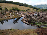
It was only a bit over an hour before the crazy steep switchbacks through the forest were over and the trees receded to a big, open wet meadow. Right next to this, there was a sort of pond that was created by beavers that were an invasive species brought in from the United States. From here, I could see up across to the peaks that rose up from the lake.
I could also see the peak that I was going to climb. It looked rather steep once again, but I just had to suck it up and put in the effort to get first across the wet meadow, then above the vegetation, and on to the steep scree that would take me to the top. It looked like once I hit the ridge, it would be smooth going. It was so quiet on this day. I had passed just one group below and would pass one other person coming down from the top on my way up. This was so nice considering how busy the park was and how few the number of trails. I think people just like to sleep in much more than I do, because it seemed like this during the entire trip that people hit the trail much later than me.
As I climbed the steep slope, I could see the ocean (bay?) once again come out to greet me. This was what made this area so inviting was seeing all the water and all the mountains together. I was feeling so good and moving so well that soon I hit the ridge and it was smooth sailing. I kept going until I hit the top. I am not sure what was considered the top of the mountain to most, but I had to do a little bit of scrambling to get to the actual top of the mountain.
The view was nothing short of spectacular. I could see all the remote mountains that rose up above the lake. I could also see the ocean and the mountains near Paso de la Oveja that we had just visited. And I had this entire view to myself. The climb had only taken a couple of hours which I thought was fantastic time for all the elevation I had to gain. I was lucky to find a trail that was in such good shape.

I took my time up on top looking out toward Ushuaia and dreaming of the mountains that I would probably never get to climb.
The weather had just been fantastic, just slightly windy but nothing like near Fitzroy. I was happy that I had been able to climb 2 mountains in Patagonia even if they had not been incredibly difficult. As I started down the mountain, it kind of felt like starting my journey home, one that was going to be a very long journey. We still had quite a bit of time left to get home, but no big adventures planned in the near future. I saw many people going up including the group of Israelis that we talked to the night before.
 They seemed so surprised that I was hiking down rather than up and that I had already made it to the top of the mountain. I passed them at about the beaver pond area and after that it got even more annoying with the questions about where the top was, especially when many of those questions were in Spanish. Also, most of the people looked like they would never make it. If we in America think our people are unprepared for what they do, the people hiking in Patagonia seemed even worse.
I made it to the bottom of the trail, but was still feeling like hiking, so I went out on the trail along the lake.
The highlight of the lake hike was supposed to be something referred to as Hilo 42. I am not sure what that meant, but when I got to it, it was a strange looking monument that was completely covered in graffiti. What made it significant was that it was right on the Chile - Argentina border. We were still technically in Argentina, but on the other side of this marker was Chile. I snuck into Chile for a little bit, but turned around and went back to camp. I still had a lot of the day to waste away while I was there. I finished reading The Girl with the Dragon Tattoo which was quite an engrossing novel, while my dad read Sherlock Holmes stories. I switched with him for a while, but Sherlock Holmes really could not keep my attention. I was going to have to get another book before I went back home. 

Thursday, January 19, 2012

Paso de la Oveja

 We awoke to a cool, but clear day. We were happy to pack up the soggy tent and get onto the trail again.
We had a shorter day planned for today, especially the uphill section. The toughest climb of the day was probably the steep section up from the lake and then back over to our trail junction for the lake. We continued up toward Paso de la Oveja. At first the trail went through a beautiful meadow.
Eventually, the meadow gave way to scree. I was feeling pretty good on this day, so I was moving ahead of Dad for some time. There was no big rush as this was not expected to be a long day. The views were fantastic once again and there was no reason to complain about a hike like this. The trail was easily discernible, but no trail was really necessary as we slowly climbed up to the pass. Once we got to the pass, it was actually hard to tell we were at the pass because it was such a gradual change. As we moved down and could see the valley below us, we had to pull out the map as the trail went a direction that we did not expect.
Instead of going down the hill, the trail instead traversed the scree. The forest looked so inviting below, but I guess this was a bit easier. The map did not seem to agree with the path of use, but we figured they would eventually meet up. We could see all the way down to the water below. It gave us a good gauge on where Ushuaia was located. This was an amazing valley and after walking up the forested section to get here a couple days earlier, we were happy to be able to not have to fight the brush.
 Eventually the trail led all the way over to where we were running out of scree. It was rather steep so I was wondering when we were actually going to go down, because it would probably be pretty steep.
I was right and on a big scree flow, we started switchbacking down in what seemed like an endless amount of switchbacks.
I love the picture of Dad in an endless amount of scree. It looks almost like a Where's Waldo picture with the main difference being that instead of being lost in a crazy amount of people, Dad blends in with the rock. These switchbacks ended with us entering the forest and we were almost immediately missing the steep scree. The trail was in very bad shape as work on it probably had not been done in years. There were so many trees down all over the trail.
It made it challenging to find the trail as flagging was used in places to mark it. It also slowed us down considerably as ducking under and climbing over downed trees can be challenging with a full pack on. Eventually, this trail led us to a road that made the going much easier. This road put us on private land. We cut off near the bottom of the hill and did some cross country that took us through a BMX type park and then out to the road. Our goal was to hitch a ride out to Tierra del Fuego Nacional Parque to camp there for a couple of days before having to begin the journey back home. The ride was tough to get, but eventually a van came by that would give us a ride. It was a short trip to the park where we would be able to have one more adventure before leaving for the United States.

Wednesday, January 18, 2012

Cerro Falso Tonelli

We had a slightly soggy awakening. During the night, we had our first rain and there was some fog around. Still, thus far it had not been very significant. This was going to be a pretty fun day as it was dedicated just to exploring the Valle Superior which was the side valley that we were in as yesterday we charged up the Valle Andorra to get here. We awoke by the lake to our smelly neighbors who built a gigantic fire to keep themselves entertained. After breakfast, we just put on the day packs which felt good to not have the full load for the day. 
We charged back up the hill above the lake and took a right up the valley. Dad was not exactly ambitious as we had a big day the previous one, so he was not quite in the mood to go too far. We decided that we would at least go to the upper lake together and then split up. The clouds really made the mountains and lakes seem more rugged. The weather was cool and damp, but still not uncomfortable. 

We struggled to keep our feet dry as we charged up the stream. I knew that eventually my feet were likely to get wet, but I figured the longer they stayed dry the better. We did not gain much elevation to get to Valle Superior.
We spent some time looking at the map trying to figure out where to go next and the most logical spot seemed to be to go around the lake and continue up the valley. We were now surrounded by peaks on all sides. Getting around the lake wasn't too easy, but it wasn't bad either as we just had to go up and over a little bluff. As we made it around the lake, Dad and I split up for the remainder of the day. I threw on the iPod and enjoyed a chance to move at my own speed.
At first it was a mainly flat valley going right past a beautiful cascading waterfall. I followed the other stream up for a little Patagonia canyoneering. Okay, maybe it wasn't at that level of canyon hiking, but I just went upstream on the soft vegetated banks of the river.
 The stream first went in a meander so calmly that it made for a hike that I could really enjoy. After a while, though, it became steeper and I had to move up away from the stream and on to a scree slope above it. Still the travel was not difficult just wet as it was slightly raining on me for most of the day. It did not hinder my progress and eventually I came to a saddle between two peaks.
The view from this spot was tremendous and I could see over to the next valley that had a green patch in the lower levels but was mostly just rock and ice. I looked on the map that I was carrying and realized if I headed up to the left, there was a peak that was not too far away. I went up and without anything more than second class hiking I was able to climb to the top of a Patagonian peak. The name of this peak was Cerro Falso Tonelli. I am not sure what that meant or where the name came from, but I was happy to be standing at the top of something even if it was a big flat summit on an island with lots of much more burly peaks above it.
 The view was absolutely spectacular! I think that this could be my favorite spot in all of Patagonia that I visited. I spent quite some time on the summit just soaking it all in and taking more pictures than I had taken on the entire trip.
I had a 360 degree view that was literally 99% rock and ice. There was some vegetation to be seen, but not an incredible amount.

 The peaks to the north were incredibly dark with the clouds hanging over the dark rock adding to the viciousness of these remote peaks. As I said before, one could easily spend a whole summer here just bagging peak after peak. It would be a lot of fun and this area truly gave me the feeling of being out away from people.
 There was a pile of rocks with a stick standing straight up to let me know that I had reached the summit. I appreciated the knowledge, but I think I may have been able to figure it out for myself.

 The nice part about a hike like this is that I just knew that I was going to have this summit to myself. Dad made it about as far as the vegetation went and then turned around.
Eventually, I did have to turn around and come down. I felt like I just flew down the scree slopes to the creek and then down the creek to the lake. I beat Dad back to camp, but just barely. I also barely beat the heavy rain and fog.
As the night went on, the lake was lost in the mist, so much so that we could barely make out the little lip of land that jutted out only a few feet away. Unfortunately, we decided this lake would be suitable for drinking water like the lakes of the Fitzroy region. The difference was that this lake was a little more stagnant. The campers here probably did not all behave responsibly considering the messy campers that were nearby that should have tipped us off. It did not and we just dipped out of the lake. We would pay for this decision a week later, but for now we just tried to stay semi warm and dry as the rain came and went all night long. I was into my book quite a bit, so that kept me busy as the rest of the day was just a nice lazy day preparing to go up to the pass and back down to Ushuaia.   

Tuesday, January 17, 2012

Laguna del Caminante

Our taxi took us up some back dirt roads that led to a gate. We thought when we got there the trailhead would be rather easy to spot, but it wasn't so it was a good thing that we had a map and somewhat of a route description. There was another group there that was going on a different hike and then one singular guy that we saw for a brief amount of time and then not again. Our goal was mainly to follow the creek up the mountains toward a pass. 
We thought that there would be some sort of trail, but after a while it seemed to disappear. I looked at the map and saw that the trail left the creek, so we thought about finding it again. The problem was that even though the area seemed like it was full of open meadows, it actually wasn't. Instead, it was filled with peat bogs. It was definitely low impact hiking as we traversed through the peat, but far too slow to make any noticeable progress.
So after sinking slowly into the ground and moving too slow, we found our way back down to the creek. There was not a trail for a good amount of time. We ended up having to cross the creek, which wasn't too bad, but since Dad has a foot that takes some maintenance, that also slowed us down.
Eventually, we found some trails to follow. They would go for some time, then disappear. It was probably because the area that we were in was open range, especially for horses. We actually found some large horses that we followed for quite some time until they let us by.
We knew we would have to find the trail again at some point, but luckily it was open enough for us to continue to see where we were going. We could look up and see the mountains rising in the distance, but that distance became smaller and smaller after some time. We even saw an extremely large hawk just chilling out. We thought this was a rather unique sight, but we would see more and more of these birds down in Tierra del Fuego as the trip went along. They actually filled the niche that would usually be filled by ravens as they became rather friendly birds at camp areas.
We left the river and stumbled upon a much better trail. This one lead away from the creek for sometime and suddenly markers started to appear. We were happy about this as it gave us confidence and we could stop wondering whether we could find the trail and instead just plug away.
We were even more convinced when we came to a creek crossing with a bridge. Instead of having a railing to it, this bridge had just a piece of wire to hold onto. I wonder what would have happen if we would have fallen. It probably was not something to hold onto, but it did help us keep our balance.
After this initial crossing, the trail began climbing. We had many steep switchbacks up into the forest. This was good because it meant that we were getting closer to our campsite. Dad was moving well and we had plenty of daylight, but it had already been a long day. We were ready to get into camp and have a relaxing evening.
Before this could happen, we had another crossing on a not so good bridge over a much more painful and cold drop. Dad thought I wanted him to bite it into the creek when I took a picture, but it easily could have ruined our day. After this crossing, we still had a bit of uphill through the trees wondering the whole time if we would have a good sign of where to go to camp for the evening. Our goal was Laguna del Caminante.
We were happy to see the only sign of civilization in this wilderness when we stumbled upon the sign for the lake. We were happy to take this because it meant the end to our uphill hiking and a trip to our campsite. It also meant that we were above the trees and our views were starting to open up.
The mountains in this area looked incredible and one could spend an entire summer just in this one area accessing all these many mountains. I wondered how many of them had been climbed and how many times. This was definitely off the beaten track even though only a few hours earlier we were in Ushuaia in civilization.
The trail traversed above the creek through a meadow. As we came around the corner, our view opened up even more and we could see the lake along with many snow covered peaks.
This looked like it was going to be a pretty sweet campsite. As we got to the other side of the lake, we could see a stand of trees where there were a few tents pitched. We had to go down a steep slope that was very eroded to get down to the lake. It was slick and we had to be careful to not end up with a soggy bottom.
As we got to the bottom of the steep slope, there was another double sided waterfall that poured into a pool of water.
We wandered around the camping area looking for a decent site. There were a couple other parties that had kind of taken the best of the lake sites. We chose to move back away from them and be in the trees a little bit. This was a bit less scenic, but quieter. Our neighbors did not seem particularly friendly, so we kept to ourselves. The weather was looking like it was going to turn as the night wore on. We had such great weather the whole trip, it was inevitable that the weather would get nasty at sometime. We prepared for a soggy day hiking the following day.