Wednesday, December 30, 2009

New Years' Eve Eve Hike

We didn't get out much when staying with my mom, but we did get her and Carl to take us on a short hike to the confluence of the Ohop and the Nisqually. It was about 3/4 of a mile down a closed dirt road. We had some good weather and we were leaving the next day. Afterwards I got food poisoning and wondered if I was going to be able to get on the plane. I threw up and felt a lot better by the next morning, though. Jacqueline and I were able to celebrate New Years' in Norwood. Wahoo!

Friday, December 25, 2009

Christmas Hike

Merry Christmas everyone. Sounds like a good day for a hike. We spent the morning exchanging gifts and then headed out to the Elwha for a hike. I really like the Elwha because even in winter it is at low enough elevation that we can access a good stretch of trail. We decided to hike out to the Goblin Gates and see how we felt from there. All four of us did the hike and it was a beautiful day to be out. Dad wore his Santa hat and looked the most festive out of the four of us. From the gates, Jacqueline, Dad, and I took another trail that led us to Humes Ranch, while Laura returned the same way to the trailhead. The cabin was definitely restored and was a homestead over a hundred years ago. It is funny how we pay attention to those things when they are inside National Parks, whereas if that same homestead was outside of the park it would be built over possibly by family members of the original owners without two thoughts. This trail looped around and ran us into another cabin and then eventually the trail back to Whiskey Bend. I think our total hike was four of five miles, but it was nice to get out and enjoy the day instead of just sitting around eating all day long.

Tuesday, December 22, 2009

Birthday Hike

It was Jacqueline's birthday, so naturally we had to go for a short hike. We were visiting my dad and Laura in Port Angeles. The day was supposed to be pretty nice, so we thought that we would take a drive up to Hurricane Ridge. They kept the road plowed most of the time in the winter, so you could get up to high elevation by just driving. The views were excellent as we could see all the mountains in the distance. It was a bit chilly out, but we kept our little pregnant birthday girl bundled up. We first hiked up the hill and out to a viewpoint. From there we went into the visitor center to look at maps. Next we hiked up the road a ways. Laura stayed in the car for this section, but my little pregnant birthday wife kept trekking. Jacqueline's mantra throughout this whole pregnancy has been, "I don't wanna do too much", but she has been trying to keep herself active even if my coaching takes me away too often. We hiked about a mile and then turned around feeling that our trek was sufficient. I realized that I had been to all of these places before, coming by myself in February 2003. It was really good to get out and after that we were back home for a birthday dinner and presents for my wonderful wife.

Friday, November 27, 2009

Thanksgiving in Canyonlands

Brian and Angela Hays invited Jacqueline and I to come stay with them out in Island in the Sky and celebrate Thanksgiving. We were all for it as I have known Brian and his family for many years. We are only a couple hours drive from them, but found it hard to make the trip with work commitments. Having the whole week off from school at least, not basketball though, we took the couple days we had and made the drive. Brian had to work, but he was able to take the whole crew on a hike. It was only a short hike but was perfect because it was good for the pregnant wife and the rest of the whole crew too. There were eight of us total as Angela's sister made the trip along with Brian's sister Sarah, his bro Matt, and his mom. We took it nice and leisurely enjoying the desert and the slickrock as we went. Even thought the air temperature was a bit chilly it was still a great time to be in the desert as the snow was not going to stop our progress. Brian had a funny moment on the hike when he pretended to be giving us a guided hike interpretational tour when another visitor came by. That visitor began following us, so he increased our party to nine. Brian was nice to him and you had to feel for someone who was alone for Thanksgiving. That is definitely a holiday where I appreciate my close family of Jacqueline and the baby growing in her tummy. We were only out for a couple of hours because we had to go back and make some turkey dinner. We all crammed into the shed at Brian's house and had an excellent dinner. We played games in the evening, including Brian's newly learned favorite of Ninja destruction. Anything that involved strength, quickness, and a small bit of pain are activities Brian will always participate in. The next day we took a drive to the La Sal National Forest where we picked out a Christmas tree. Ours was rather small because we don't have room to put it in our house. The rest of the crew continued for a day of play in the sun and snow, while we had to return to prepare for a long basketball season.

Sunday, November 22, 2009

Black Canyon of the Gunnison

We had the week off due to Thanksgiving and we had not been out much since basketball had begun. I was crazy busy and Jacqueline was quickly getting crazy pregnant with all the joys of pregnancy including the morning sickness which does not just happen in the morning. We had to pick an easy place where it would not be too challenging for Jacqueline. We picked Black Canyon because it was not too far away and the trails did not seem very long. We drove up and it was free since it was the off season. Our first goal was to go out to all of the viewpoints we could handle. It was a rather unique place because it was much different from the vast Grand Canyon. It was so incredibly vertical. We wandered through the snow on the short trails out to the viewpoints to look down and see the big drops. Finally we drove to the end of the road and took the longest trail on this side of the park. We hiked the Warner Point Trail out to Warner Point. All in all only about a two mile walk. There were some icy steps to negotiate, but for the most part it was just a pretty hike. We got some good vertical views down to the river and on the surrounding cliffs. We took a look to try to find the route down to the river and while there seemed to be a few promising spots, the crusty snow seem to cover up any discernable trails. We will have to come back when there is no snow, but not when it is too hot either. All in all an enjoyable day being tourists in a park that neither of us had experienced before.


Sunday, October 11, 2009

Wilson Mesa Trail

Fall was quickly turning to winter as the mountains from our front porch were starting to get snow covered. We knew we only had a few more weekends of good hiking left. We went back out to the Woods Lake Trailhead, which was quickly becoming one of our favorite places to go. We thought briefly at attempting to climb Little Cone. It looked like a gradual slope to the top, but thought better of it and instead chose to hike the Wilson Mesa Trail. We parked a ways above the trailhead since there was no parking there and walked back. The trail was in good shape and almost immediately we saw a very scared coyote. We were happy to see it, but you could tell he was sketchy of humans. We learned that in this area people just shoot coyotes for the fun of it, so it was not surprising. The trail climbed steeply at first, but then began to level out. It was a perfect trail for Jacqueline now a month pregnant. It climbed slowly through the trees which were just on the edge of being too late to see much color. There was actually more color on the coniferous trees looking like Christmas trees decorated with Aspen leaf ornaments. The views of the jagged peaks around Mt. Wilson were excellent today. It made me excited for the next summer when we could go climb those peaks possibly. The trail hit an old road and we followed that until it became the Elk Creek Trail. We took this one uphill. If we would have had a map, we would have realized that this trail met up with the Navajo Lake trail and we could have made a loop. Not feeling too ambitious with a pregnant lady, we decided to call it a day after between 4 and 5 miles. We had to come back the same way and putting in more than ten miles might be a little too much for the zygote growing in Jacqueline's belly. A quick picture and then back down the same way. We took our opportunity to soak in the mountain views as we knew we may not get another opportunity to get into the mountains for a while. We finished nicely and I was proud of Jacqueline for still getting out even growing a little baby.

Sunday, October 4, 2009

Come on Ride the Train

Occasionally I will break away from backcountry experiences in the blog. Celebrating the best decision I ever made in my life I believe is a good enough reason. It was our anniversary weekend and Jacqueline had really wanted to take the train ride from Durango to Silverton. To make the process easier for us, we figured out that you can take the train from Silverton to Durango. This was an odd way to do it, but it was much more convenient for us. We had to meet the train about 3pm in Silverton. So we took the drive over the pass going up from Ouray. Crazy road with steep drop-offs on the sides, but very beautiful. It dropped us into Silverton just in time for us to get our tickets, get some lunch and wander around. We found our train and had a good conversation with one of the workers. Jacqueline was worried because something happened to one of the trains on the way up, but we were not worried. Once we finally got on the train, we were sitting right next to a crazy family. We had some great views of the river, the trees, the mountains, waterfalls, and eventually the city of Durango as we pulled in 3 hours later. This put us in at around 6pm. Once we checked into our hotel and Jacqueline got herself ready, we hit the town for the anniversary dinner. The problem was that restaurants were mostly full being that there was some Cowboy Poetry deal going on in Durango. We wandered forever and were unsuccessful. We actually went back to the hotel and went swimming first and then went back out for a 9pm dinner. We found an Italian restaurant where we were able to get some decent food. After having a sleep, we awoke to go get some breakfast and then back on the train. Today was our actual anniversary, so we got an anniversary picture. We were both a little bit more dressed down than last year at this time. Today we were next to a bunch of French people who talked insanely loud the whole time. We got to sit on the side where we saw all the drop-offs today to the river. You could tell there was a lot of ingenuity in building this railroad. We were seeing the end of the trees changing color at high altitude. The train ride was fun, but long and slow. Jacqueline and I both agreed that we were glad we did it once, but once was good for the both of us. Now we just had to drive over the pass again and lucky for us it was snowing. I was nervous, but we did fine and made it back safely. One last photo is the bumpdate. Not much, but you can see it is something after less than a month.

Saturday, September 26, 2009

Aspen Fall

When we climbed Lone Cone in August, we drove by a trailhead for the Goat Creek Trail. We figured that was worthwhile to check out because it was so close to home. So we drove back up there. We parked right off the side of the road and started walking up an old dirt road. Immediately we knew the appeal of this trail was the multitude of beaver dams. It seemed every hundred feet there was a new dam. Trees all around us showed the scars of beaver chewing, but of course we never saw an actual beaver. There was so much hard work put into these dams that you had to respect the industrious beaver. The trail did not take us very far and soon it ran out. We vowed to keep following the creek even though we did not have a trail. It took us through underbrush and through the aspens until we ran into a fence. Here we were in the evergreens again. We walked around the fence until we found an opening. Here we made our way to a road
on private property, but that did not last for long. We crossed the creek again and found the best patch of aspens we saw the entire day. Really what you are after on a fall hike with Jacqueline is to see the pretty trees. We wandered amongst these, contemplated the thought of hitting a road far above us and making it a loop hike on some dirt roads. We thought better of it and came back the way we came. With only a couple hours out so far, we decided to continue driving and see what we could run into. About an hour drive got us to Beaver Park which was a pretty little area with excellent views. We found another trailhead which was the other side of the Lone Cone Trail we had taken a few weeks ago when we climbed Flat Top. We decided to hike it even though Jacqueline was not feeling to wonderful. She struggled the first part of the hike, but started feeling better after we got into it for a bit. The hike took us through many aspens and coniferous forests. We decided we could not go for too long and stopped after some cascades and a creek crossing. We knew from here it was a steep uphill climb and Jacqueline was just not feeling it on this day. We did not see much wildlife on this day, but we did see more than we saw humans. It was unbelievable to us just the quiet of these trails after running into so many people in Zion. Nope, for us on this day it was just the squirrels to keep us company. The walk out was pleasant as we headed downhill with ease. We enjoyed the bright yellows all around us that warned us we were in for some much chillier temperatures in future. A few days later, we realized why Jacqueline had not been feeling super well on the hike. She was pregnant! We were super excited that we were soon going to have a wonderful little one to come exploring with us in the future.

Saturday, September 19, 2009

Taylor Park

We drove out for the weekend to see the Fords at their place in Taylor Park. Greg and I coached together for one season at Boulder High. Since then, we have become friends. We were only living about 3 hours away, so we left after school on Friday to drive to Taylor Park Reservoir where Greg and Fern have a house and a business that they run in the summer. The drive was longer than we expected as we ran into a bit of rain and cows on the road. We made it to their house a little after eight where they had dinner waiting for us. The house use to belong to Fern's mother. We visited with the Fords that evening. The next morning after breakfast, Greg and Fern took us to an abandoned old mine. This area was big mining country. There were so many pieces to this old mine being a place where ore was processed. We continued up the same road until we were forced to stop. Then we followed an abandoned road up from there. This took us through the trees until we eventually reached treeline. This was not hard to do being that Taylor Park was located at 9300 feet already. The seasons were short here and we could already begin to see the Aspen's changing on the slopes on the other side of the mountain. You could tell that we were all acclimated because no one had trouble with the elevation even though at one point we were walking on the Continental Divide Trail. Even Jacqueline was doing fine regardless of the fact that she was now a week pregnant (still unknown to us at this time) with our daughter Zyla. Our end goal on this day was an old mine. We could see it across the mountain and we eventually made our way up to it. It was rather interesting with old engines from a vehicle, tailing everywhere, and lots of old parts. You could tell that at some point in history this mine was rather productive. I believe it was a copper mine because we were able to find the turqouise colored rocks scattered about the scenery. We had lunch there and went up to the old mine entrance. We could not go in because it was long ago closed off. We were only a few hundred feet below the continental divide at this point, but that was not our goal on this day, so we headed down. Greg and Fern took us up the road a short ways to an old town call Tincup. They had a cabin there. This town was located above 10000 feet and was only accessible in summer and by snowmobile in the winter. It seemed like a very relaxing place where it would be easy to just kick back. From there we headed down the road to check out the reservoir and watch the fish jumping at the bottom of the dam. Back at their place for a night of hanging out and watching replays of UW's victory over USC. Go Huskies. We left the next morning to get prepared for the school week, but we sure had an enjoyable experience spending some time with the Fords in Taylor Park

Monday, September 7, 2009

Flat Top

When Jacqueline showed up in Norwood, we immediately made our way out for a hike that weekend. Unfortunately, our camera was out of battery so we did not get any pictures. We made our way high up into the mountains nearly to Navajo Lake from the Woods Lake Trailhead. It was a great hike where I was recovering from a cold. I got the sniffles when I climbed Mt. Sneffels. Lots of beauty, but no pictures. We went back out that same weekend thinking that we might want to return to get some good pictures. Instead, we decided to take another trail that left from the same trailhead. Strangely, this trail was named the Lone Cone Trail, but we were nowhere near Lone Cone Peak. Instead we were heading off in a direction that I was unsure about and so was my GPS as the trail was not on my map. It had rained the night before so everything was wet on the ground. Luckily we had a good trail that we figured must go somewhere, so we followed it. It lead us through a beautiful Aspen forest. In fact, much of the hike was enjoying the gorgeous Aspen trees that rose all around us. We came to junctions in the trail, but each time we took the one that went uphill. It soon began to climb steeply. When the trees finally opened up, we were able to get some excellent views.
We were able to see right to the area that we were at a couple of days earlier as we were right above treeline along the peak that rose in the front of the range right behind it. We continued to climb until we came to a spot where our good trail changed into nearly non-existent with lots of trees down all around. We fought through the trees and then decided to forget the trail anyway as we were right on the saddle between some peaks. The peaks to our left were massive, but the one to the right was close. The name of the peak was Flat Top and while not a very exciting name, it still was a mountain with a name which to me made it seem interesting enough to climb. We began to head up through the trees. We followed the trees on the ridge for as long as we could until it turned to rock. Jacqueline started to get a little nervous with the loose rocks, but she did not have much time to get nervous, because almost immediately we popped out on the summit. We got some great views from this truly Flat Top Mountain. We could see Little Cone rising off to the south with a summit that looked fun and not too difficult to get up to. We could see our previous conquest Lone Cone to the west. We
had great views all around us with a wind free and peaceful summit to enjoy. We could see mountains all around us that were yet to be climbed (by us that is). As we watched the afternoon thunderstorm clouds start to roll in, we quickly ate some lunch and wandered back down the trail. We ran into only one other person on this day and we were quickly learning that we were lucky to be in this beautiful area where many others were not lucky enough to be weekend warriors in. We took no detours on the way down; seeing the same scenery as on the way up just at a faster speed with a little less oxygen being inhaled. The only major wildlife sighting we got was in the campground where our car was parked. Rummaging through the camp hosts site, which was vacated that morning as we saw a speeding motorhome on the dirt road, was a porcupine. Jacqueline and I were both pretty stoked about it because we have seen tame porcupines, but never one that was wild together. For me, this was only the second one that I saw. It was a great hike on a late summer's day.

Saturday, August 29, 2009

Sneffels

For starters, do not ever camp at the Blue Lakes Trailhead at the end of August. That is a bad decision. I got there on a Friday night after finishing up a week of teaching. Jacqueline was still working in Zion, so I had to entertain myself in some way. I took a short walk and as soon as it was dark, I got myself to bed. I figured that would be a good decision to get some sleep. There were so many hunters(?) there with their ATVs that they were driving around right near my tent until 10pm and then again starting at 4am. Needless to say, I was up early and a little frustrated. Right as I was getting ready to set out on the trail, a guy with a big truck stopped to ask me if I knew where something was. I told him that I just moved here and have no idea, but who was he looking for at 5 in the morning. I left that scene behind me and was soon out on the trail. I was moving quickly as the trail started out in a wooded area on the side of a big ridge. I wondered when I would get a view of Mt. Sneffels considering I had no idea what peak it was. I was starting to see some mountains as dawn light was crawling its way across the skyline. The Blue Lakes was a short hike from the trailhead and I was beginning to approach it at 7am. There was a big waterfall pouring down so I knew I was getting close. There were many campers asleep as I came upon the lakes. I figured that this would be a good place to camp if I was to venture up here again. I had breakfast at the lower lake. It was pretty with the peaks rising right out of the cirque that the lake filled. There was a bit of snow left on the peaks above. I wondered what the blue color was as looking at the lake in the early morning hours did not make it look particularly blue. I found the trail from the campsites and made sure to not disturb the parties fast asleep. This is where the trail began to climb steeply. The trees started to melt away and soon I was hiking through the high alpine scrub. The trail was bomber at this point as I approached the middle lake. It looked very undisturbed so I made sure to throw a rock in it. Just around the corner from the middle was the upper blue lake. This seemed to be the largest and it also was in a large cirque. From here the trail climbed steeply. Switchbacks after switchbacks and as I looked above, I wondered how the trail could manage to be built on such a steep area. I quickly realized when I got there that it was not very well built. The trail became very small loose scree that took much effort on my part to avoid slip sliding away as Paul Simon would say. I was actually a little bit wrecked in the nerves when I finally got to the Blue Lakes Pass. This put me right at a great vantage point to check out Mt. Sneffels. I could not figure out what was the right way to go from here. There was a jagged ridge that climbed directly above where I was and there also looked to be a steep scree slope on the other side of the mountain. My three choices were to either climb the ridge directly in front of me, go down and climb the scree slope, or go back from where I came and say screw climbing this peak on this day. I chose option 1 after considering each one after I saw a party with yellow helmets climbing above me. I figured I would follow them. This was definitely the more dangerous decision as there were some places where I was actually climbing, climbing. I believe this would be either considered 3+ or 4th class. I figured out soon enough that I was taking a different option to get to the top of this peak. Eventually I caught up with them and talked to them for a bit. They were a nice couple. I broke away from them since they were moving much slower, but eventually bumped into them again when I took the wrong route. I was able to pick my way through until I hit the normal route. From there it was smooth sailing to the top where I carved a place from the mass of people. Up until I reached the summit, the only people I saw on this day once I hit the trail were these two people with yellow helmets. The summit was filled with people as I hit the summit at 10:30AM. I enjoyed the view from the top of this 14+ summit which was awesome. The San Juans offer a multitude of craggy peaks to gaze upon. I got one of the many to take my picture and then was on my way down. I chose to go down the easy route and this was a good choice. While also steep with lots of loose rocks and a lot more people, it was definitely the safer alternative. The other way I felt at times that I had to reach the summit so that I could get down this easier way. It proved to be the greater choice even though at the bottom I still had to go back up to get to the Blue Lakes Pass. I knew that the rest of my day would be relaxing once I got past the steep sections on the trail. I was successful by sometimes butt sliding and other times moving inch by inch. From there it was speed hiking as it was all downhill. As I passed the upper two lakes, I got to see the lower lake in full blue. I could see why this would be a popular destination. I enjoyed my lunch as I sat on a big rock and soaked in the scenery.
It was only ten after one as I made my way through the campsites and down the three mile trail to my car. I was back home by four thirty and the afternoon as I appreciated the beautiful areas that surrounded my new home in Norwood, Colorado.

Saturday, August 15, 2009

Lone Cone

Well the day to finally make the big move was here. Jacqueline's dad and my dad both came out to help us pack to exit Springdale for Norwood, CO. My dad came with us to drive our U-haul the nine hours. We made it without any problems. When we got to our new home, there was a lot of work to do. The grass was growing out of control. There was wood scattered everywhere. We also had quite a few bees' nests around the house. To add to that, we had to unpack and I had to start work. Without my dad and Jacqueline to get to work around the place, I would have had weeks of work to do. While I figured out how I was going to teach math this year, my dad weed wacked, chopped wood, painted with Jacqueline, while Jacqueline organized the pad. I helped a little in the evening, but I learned how overwhelming the whole process was going to be of teaching six classes my first year teaching.
Eventually on a Saturday, we all took a break. There is one peak that overlooks the town of Norwood and it reaches 12613 feet above sea level. I knew that eventually I was going to have to climb this peak, so why not get it over with immediately. We got all our stuff together, except for our camera which we foolishly left on the porch and loaded into the Xterra. We had some dirt roads to navigate, but with the GPS and some directions we made progress. We made some right turns, but for some reason missed an easy dirt road right in front of our faces and lost some time getting to it. We finally made it and I got a lesson in 4WD as we had to use it for the last four miles. Eventually we found the beginning of the hike and we were on our way.
We started out on an old dirt road that went through the trees. Soon it opened up and we got a good view of the mountain. It looked rather large from where we were standing, but this was definitely a mountain with some depth perception issues as we were already at quite a high elevation. We entered back into the trees heading straight for the mountain. 
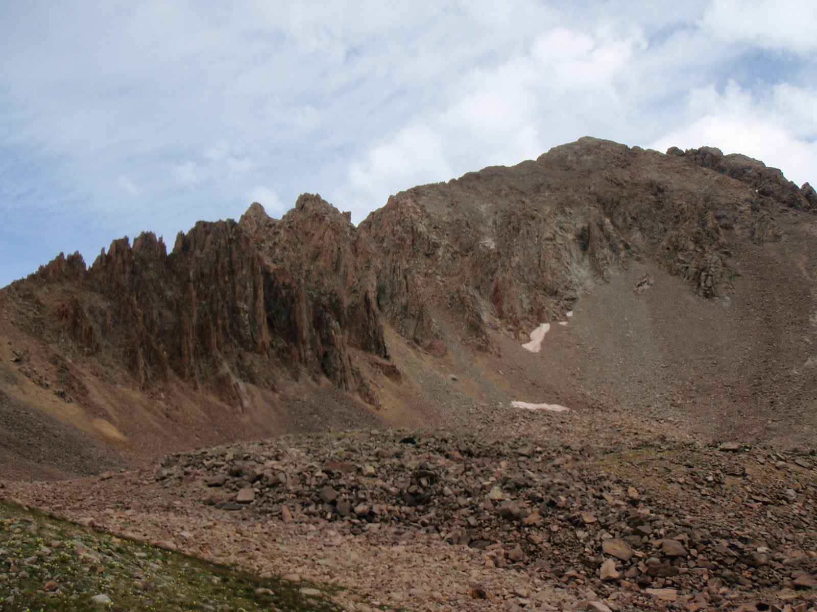
We found ourselves on the eastern side of the mountain, but we knew we wanted to go up the Northwest route, so we had to traverse along the base of the North Face. This was all alluvial deposits from past avalanches and rockfalls. It was downhill, then rocky, then uphill until we hit the ridge. The beginning was vegetated with a bit of scrub, but soon we were above treeline. I was feeling good and the crew was trailing behind. Jacqueline was not a big fan of the steepness and the loose rocks. She was doing well just moving a bit slower than usual. The old man was moving steady. I knew I would never feel this good again coming straight off my season of backcountry. 
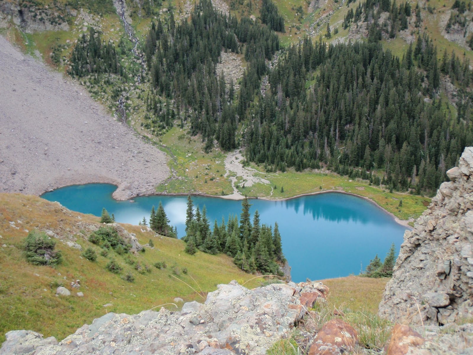
The top kept inching closer and unlike other mountains we could see the actual top. As we swung around, we could see both sides of the mountain dropping away, one steeper than the other. The final push was on and we made the summit. It was only 10:30AM when we stood on top. It was a nice summit with a long view on all sides. Lone Cone is the first peak as you approach the 14ers, but it really did not feel all that big. We had the whole mountain to ourselves on this day, though and we could enjoy the summit. We took some pictures, had our brunch, and were on our way back down. Jacqueline was a little worried about the steepness of the terrain and she was taking her time on the way down. She was half butt sliding, half walking. Eventually we got to less steep terrain and she was a little more comfortable. It was beautiful to be in the mountains, so different than the hundred degree weather we were used to in Zion. Eventually we got down to treeline and had to traverse our way back. We got a little off course, but found our way back to our route. I was using the GPS and while helpful, it did not do the job of a sense of direction. We were back to the car just a little bit after noon with a lot of the day still left to go unpack our house. It was great to spend the day with my beautiful wife and my dad climbing a mountain that we would soon see from our house every day. Soon my dad and my wife would leave me to start my teaching. Jacqueline was going back to finish work, while dad was done being helpful like a good dad can be once he is retired.