Finally, I made it! It was not easy, though. It was quite a trip out to Chasm Lake. It started Wednesday night when Jacqueline got off of work. She was done at 4:30 and our plan was to meet Rich, who is a backcountry ranger out at Kolob, at campsite 16 to stay before our trip up to Chasm Lake the next day. We got to the trailhead at 6:00 pm and started down the trail. Not too long into the hike, the sun went down and the nearly full moon came out. We strapped on our headlamps after trying to use the moon, but the trees were a little too thick. One headlamp was broken, so Jacqueline used my new state of the art magnet powered, $5.99 flashlight. It worked okay and we strolled along the trail to campsite 16, doing about 8 miles in 3hr 15min. We met up with Rich who was watching the moonrise. We chatted for a bit as we put up the tent and got ourselves situated. Without too much time to chill, we went up to a blissful backcountry sleep. We awoke early enough to get a quick start at 8am. We went up to Beartrap to filter water and let Jacqueline have a look at the falls. (For Beartrap Falls pics, see La Verkin Creek backpack in August)
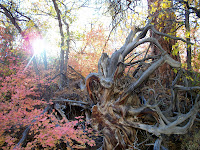
 We continued up La Verkin Creek until we met up with Willis Creek. We took that for the next couple of miles through the forest with lots of fall colors all around us. Then we hit the open valley near where the route to Chasm Lake starts. If you flash back to my La Verkin Creek backpack, you can see where from hear I went up to the Beartrap saddle to try to see Chasm Lake. On this day, Rich one upped it with a trip to the actual lake. I was confident that we could make it this time, because Rich did it in July of this year with two others. He said it was not for wimps, the route that we were going to take, but it was hard to judge what that meant. The route went off to the east from the open valley through a mini-slot. From there, Rich wanted to try something new and go up the slope rather than the drainage. This turned out somewhat bad as the route became steeper as we ascended it. Soon we had to cut over and it was very steep in places. There was still enough vegetation around to grab onto unless you got some good speed going. Then we ended up back in the drainage. It was very loose dirt and rock. I was going last and constantly thinking that a rock was going to come slamming down on me. It was really steep in parts and the ground was giving way as I was walking. Jacqueline was not liking this route at all, as she was having to negotiate some 4th class stuff that she was obviously not comfortable with. I was not that comfortable either, but Rich was just taking a stroll in the park. Soon we topped out and got up to a stand of trees to take a break. This was the end of the attempt at Chasm Lake for Jacqueline. I was very happy that she decided to stop because I did not want to put her in anything over her head. Rich and I continued, and from here, we had to head south toward the lake. The only thing we had was a small, sandy, rocky ledge. We had to stay rather near the edge to make the walking easy. It was definitely the kind of stuff where on normal ground, you would think nothing of it, but with a 300 foot fall to your death below you, it weighs on your mind. Still we continued on until we got to the last great obstacle. Rich calls it the Dance Floor.
 A thirty degree sloping, thin slick rock with nothing much below it to stop your slide if you got going. All you have to keep you on that rock is your rubber soles. We handled it well and soon we were scrambling down the last bit of slickrock and approaching the lake. When I saw it, I was very happy. It takes a lot of time and effort to see Zion's only permanent lake.
  It has a nice debris dam that doesn't seem like it is going anywhere soon. The next great adventure was to cross the lake. This lake doesn't see much sun, so Rich and I knew that we were in for some cold water. We could skirt the right side of the lake without getting in over our waist, but Rich went through the first of four water stretchs and called it good. This is what people describe as bone chilling cold. I figured, "I just did some of the scariest 'hiking' I've done in my life, there is no way I am turning around now." I endured the cold and made it to the other side. There was a small meadow leading to a narrow slot.
  I took it all the way up to a pour-off and realized that Drew, Jacqueline, and I were near the top of that pour-off back in July when we went out earlier trying to find Chasm Lake. Well, I headed back from there and the last two water crossing to get back across the lake were extremely painful, almost as bad as when the doctor froze my toes. Rich and I made our way back to Jacqueline and going back seemed to go twice as fast and be twice as easy. Jacqueline was happy to see us and I reassured her that she made the right choice to stay put. The way down was much easier as the drainage was actually two drainages and we took the different one closer to the wall. It was more brushy and thus, easier for us to lower ourselves down. I definitely had the feeling of excitement when I put my two feet on the ground from where there was suddenly no slope. It was a good accomplishment for me, one that I never would have made without Rich's impressive route discovery. We made our way back to camp for some dinner and a night of card games. The next day, we leisurely made our way out of La Verkin Creek. We stopped for a quick jaunt up the Arch trail, so Jacqueline could get her first close view of that. Then we headed down not stopping except for lunch at the rapids before the climb out.
 The rest of the day was spent trudging our way uphill out of La Verkin Creek. That hill just gets longer every time we do it, but by mid afternoon we were out and ready to head back to civilization. We had a great time, though, and Rich is definitely somebody I would take other trips with in the future. He is a strong hiker and we all enjoyed our conversation as we went through La Verkin Creek area.
 One headlamp was broken, so Jacqueline used my new state of the art magnet powered, $5.99 flashlight. It worked okay and we strolled along the trail to campsite 16, doing about 8 miles in 3hr 15min. We met up with Rich who was watching the moonrise. We chatted for a bit as we put up the tent and got ourselves situated. Without too much time to chill, we went up to a blissful backcountry sleep. We awoke early enough to get a quick start at 8am. We went up to Beartrap to filter water and let Jacqueline have a look at the falls. (For Beartrap Falls pics, see La Verkin Creek backpack in August)
 We continued up La Verkin Creek until we met up with Willis Creek. We took that for the next couple of miles through the forest with lots of fall colors all around us. Then we hit the open valley near where the route to Chasm Lake starts. If you flash back to my La Verkin Creek backpack, you can see where from hear I went up to the Beartrap saddle to try to see Chasm Lake. On this day, Rich one upped it with a trip to the actual lake. I was confident that we could make it this time, because Rich did it in July of this year with two others. He said it was not for wimps, the route that we were going to take, but it was hard to judge what that meant. The route went off to the east from the open valley through a mini-slot. From there, Rich wanted to try something new and go up the slope rather than the drainage. This turned out somewhat bad as the route became steeper as we ascended it. Soon we had to cut over and it was very steep in places. There was still enough vegetation around to grab onto unless you got some good speed going. Then we ended up back in the drainage. It was very loose dirt and rock. I was going last and constantly thinking that a rock was going to come slamming down on me. It was really steep in parts and the ground was giving way as I was walking. Jacqueline was not liking this route at all, as she was having to negotiate some 4th class stuff that she was obviously not comfortable with. I was not that comfortable either, but Rich was just taking a stroll in the park. Soon we topped out and got up to a stand of trees to take a break. This was the end of the attempt at Chasm Lake for Jacqueline. I was very happy that she decided to stop because I did not want to put her in anything over her head. Rich and I continued, and from here, we had to head south toward the lake. The only thing we had was a small, sandy, rocky ledge. We had to stay rather near the edge to make the walking easy. It was definitely the kind of stuff where on normal ground, you would think nothing of it, but with a 300 foot fall to your death below you, it weighs on your mind. Still we continued on until we got to the last great obstacle. Rich calls it the Dance Floor.
 A thirty degree sloping, thin slick rock with nothing much below it to stop your slide if you got going. All you have to keep you on that rock is your rubber soles. We handled it well and soon we were scrambling down the last bit of slickrock and approaching the lake. When I saw it, I was very happy. It takes a lot of time and effort to see Zion's only permanent lake.
  It has a nice debris dam that doesn't seem like it is going anywhere soon. The next great adventure was to cross the lake. This lake doesn't see much sun, so Rich and I knew that we were in for some cold water. We could skirt the right side of the lake without getting in over our waist, but Rich went through the first of four water stretchs and called it good. This is what people describe as bone chilling cold. I figured, "I just did some of the scariest 'hiking' I've done in my life, there is no way I am turning around now." I endured the cold and made it to the other side. There was a small meadow leading to a narrow slot.
  I took it all the way up to a pour-off and realized that Drew, Jacqueline, and I were near the top of that pour-off back in July when we went out earlier trying to find Chasm Lake. Well, I headed back from there and the last two water crossing to get back across the lake were extremely painful, almost as bad as when the doctor froze my toes. Rich and I made our way back to Jacqueline and going back seemed to go twice as fast and be twice as easy. Jacqueline was happy to see us and I reassured her that she made the right choice to stay put. The way down was much easier as the drainage was actually two drainages and we took the different one closer to the wall. It was more brushy and thus, easier for us to lower ourselves down. I definitely had the feeling of excitement when I put my two feet on the ground from where there was suddenly no slope. It was a good accomplishment for me, one that I never would have made without Rich's impressive route discovery. We made our way back to camp for some dinner and a night of card games. The next day, we leisurely made our way out of La Verkin Creek. We stopped for a quick jaunt up the Arch trail, so Jacqueline could get her first close view of that. Then we headed down not stopping except for lunch at the rapids before the climb out.
 The rest of the day was spent trudging our way uphill out of La Verkin Creek. That hill just gets longer every time we do it, but by mid afternoon we were out and ready to head back to civilization. We had a great time, though, and Rich is definitely somebody I would take other trips with in the future. He is a strong hiker and we all enjoyed our conversation as we went through La Verkin Creek area.

 We headed into and then out of Clear Creek into Crawford Wash. Hiking up drainages on the east side is sort of a two-headed monster. There are two sides to them, so we started heading up. It was not too long before the canyon slotted out. Luckily, the canyon


 We made it to our trailhead after not too long of being tourists. We chose Ice Box Canyon because it looked like there may be less people on that trail. There were only seven cars at the trailhead instead of twenty-five. The trail looked like it was good for the first quarter mile or so and then it became rather rough. It was tough at times for Ginny, Jacqueline's mom, to scramble over some of the boulders in the trail. She found a nice shady spot to wait for Jacqueline, Tom (Jacqueline's dad), and I to finish our hike. Soon, the whole canyon was in the shade. We made it a fair bit of the way up the canyon


 It is 10,365 feet high and definitely a good hike for a weekend day. Instead, we followed the only discernible trail that we ran into that lead us to the Three Pine Creek trail. Well, obviously we were a little bit frustrated, but we got over it quickly and made the most of it. That trail ran into the Cottonwood-Harmon Trail. We took that out and stayed high on the ridge with views of Zion and the mountains above us. I tried out an


