School is out! That means a summer of hiking and backpacking in Oregon is in store. We shipped Zyla off to summer camp, so the three of us had a few days to ourselves to go explore. It was amazing weather for June also being a little bit cool. We had talked for weeks about going to the Rogue River, but when it came down to it, it was kind of a long drive. We chose instead to go to Mt. Jefferson area. We had tried to hike here weeks ago, but there was too much snow. A few weeks and a little warm weather had cleared that snow right out and it was now time to hit the trail. When it came down to going, though, Jacqueline just wasn't feeling it, so she decided to stay home. That meant it was a backpacking trip with just Conrad and me. This was going to be fun!

We chose to leave from the Duffy Lake Trailhead. There were plenty of permits available, but when we got to the trailhead about an hour from where we lived, there were lots of cars there. There were also lots of mosquitoes and we would spend much of the trip fighting them off. The hike to Duffy Lake we had done before. It is a pleasant hike through forest occasionally being next to a creek that would actually become the Santiam River. The trail was clear of snow, but there were quite a few blowdowns which made it challenging with the big backpacks especially for Conrad given that he was only 10 years old. He was taking it in stride, though, and soon we were at Duffy Lake enjoying a snack break.

The trail continued on from Duffy Lake and it added the benefit of going through a burn area. This made the trail a little bit warmer and the blowdowns increase in size and number. As we skirted the shores of Mowich Lake, the going became much more difficult. I never really had to help Conrad out much, though, as he handled the down trees really well. Getting above Mowich Lake is when I started to get a bit nervous, though. There was snow still here once we were back in the trees. Given that we planned to camp at Alice Lake, this made me nervous that camp would have snow. When we got to Alice Lake, though, the snow was gone. Alice Lake wasn't much, but it was a water source right near the trail that was quiet and secluded.

We got camp set up and found a nice flat spot back in the trees. We were happy to drop the big packs and after a rest break, we put on the day packs instead. We headed back the way that we came to a junction about a half mile back. We took the opposite junction that sent us out to North and South Dixie Lakes. The trail continued to have blowdowns in this section, but it was not quite as difficult to cross them without the big packs. The Dixie Lakes were really nice, but I was glad that we weren't camping out here because there weren't many live trees left. I was surprised at how much of Mt. Jefferson was burned. It had taken the brunt of the forest fires in Western Oregon thus far.

We continued on the trail which took us past meadows and awesome views of Three Fingered Jack. The goal of this little adventure was to get to Santiam Lake. When we made it, we found a quiet little lake with a few fisherman and campers. We took a break at a nice quiet spot where we both took a dip. The lake was cool but not as cold as it could be for this time of year. I was happy to cool off and Conrad was enjoying it also. We circumnavigated around the lake. This led us to a swampy section that we had to work hard to avoid getting our feet wet. It also took us by some nice campsites and I assumed that this lake would be much busier in the summer time.

We hiked back to our little lake where we spent the evening doing all the things that are fun to do at camp. We read books, played cribbage, ate some backpacking food, and hung out. There were also the chores of washing dishes and filtering water, but mostly it was just fun to have some guy time hanging out. We slept well and temperatures were comfortable for us. Sleeping in the tent with sleeping bags is always enjoyable and it was good we got a rest because we had a full day ahead. The goal today was to walk to Marion Lake and back. There was a nice big loop that we could do. So as soon as we were ready in the morning, we were heading out with our daypacks on. We could go ahead and leave the tent at Alice Lake.

The first mile started out kind of snowy. It seemed like we had found a little oasis in a see of snow at this higher elevation. The trail also started to go downhill, so I hoped the snow would go away. It started to and soon we were hiking through the woods to go check out Red Butte Lake. We were actually camping under Red Butte at Alice Lake, but this lake had a better view of the summit. From here the trail continued downhill eventually getting out of the snow and opening up quite significantly when we emerged from the forest to the more burnt area. Here we were now in the Eight Lakes Basin and the Eight Lakes Basin had seen significant fire activity recently. It was starting to recover, but much of the area was open and exposed.

The trail took us past John Lake which would have probably been an awesome lake before it burned. Conrad and I joked about the name being sort of a boring name for a nice lake. We continued on down the trail which took us to Bowerman Lake. I wondered when and who this lake was named for given that the name of Bill Bowerman was so well known in Oregon. Was it named for him or a relative of his? I probably could dig deeper and find out, but I don't have that information. Bowerman Lake was probably the prettiest lake we saw the whole day without being burned at all around its shores. It also had spectacular views of Mt. Jefferson and the largest collection of mosquitoes we would see during the day.

The trail continued on here heading toward a junction with the Minto Pass trail. We wondered if this trail had been cleared in years because there were so many blowdowns. I was happy that we decided to take this trail going downhill rather than up, because we were getting a workout in just climbing up and over all of the downed trees. When we got to the junction of the Minto Pass trail, that trail was hardly recognizable as a trail with so many blowdowns. This area had burned 20 years ago, but it seemed like just now many of the trees had decided to fall with the snowy winter that we had. The forest was starting to grow back with many 4-6 foot tall trees, but the thickest vegetation was this weird green sticky plant. After crossing hundreds of blowdowns, though, we finally made it to the shores of Marion Lake and out of the burned area. It was like hitting a light switch and suddenly we were on this incredibly pleasant trail with shade and a comfortable atmosphere. It even took us next to a cascading waterfall with a nice comfortable bridge to cross. Marion Lake was huge. It is hard to fathom the size of this wilderness lake until you are there.

We got there in the late morning and when we finally made it halfway around the lake, we had a lunch around noon. There were numerous campsites along the lake with lots of places with seclusion and privacy. Conrad was excited to see a group that we had encountered the previous day still waking up late in the morning. I guess they existed on a different time scale from us. We ate our lunch continuing on our way. The views were many of the lake and Three Fingered Jack from here and one of the more exciting parts was crossing the outlet of the lake. A huge amount of water poured out from here. We could have gone down to Marion Falls, but we already had a long hike back ahead of us.

So we went up the trail. It quickly climbed upward crossing lava fields and forested slopes. We had enjoyed an entire morning of going downhill, now it was time to hike back uphill in the afternoon sun. The temperature, though, was not bad at all and we had really lucked out with the weather. There were not many people on the trail now that we left Marion Lake, but we did get passed by some Europeans that looked like they were ready to put in a good 30 miles on this day. We passed a junction with the Pine Ridge Trail and filtered some water at a small lake where we fought off the mosquitoes out for blood. We continued through the forest until it dissipated and left us in a fire scarred area once again.

The name of this trail was the Blue Lake trail, so that is where we were headed. Along the way, though, the views were great given that the trees were gone. When we got to a high point on the trail, we stopped to take a break. Conrad hung out while I climbed up a little butte to get a better view. The scrambling was pretty easy and soon I was on top with an excellent view of the area around. So many lakes, it must have been amazing before the fires. Conrad even named one of the smallest lakes Frodo Lake after the hobbit in Lord of the Rings. We continued on to Blue Lake. We made sure to scramble on down to its shores and get a good view of the lake.

Blue Lake had some sections of trees still left and it seemed like it would be a nice quiet spot to camp. There were no other people around at this point and I am sure that we were the only people that day to do the hike around the entire Eight Lakes Basin. We continued on from Blue Lake and were soon back at John Lake. After skirting its shores for some time, we found ourselves climbing back uphill for the last mile through the snow. It was a 13 miles day which is pretty good for a kid of 10 to do especially with hundreds of blowdowns to climb over. We could spend the evening enjoying the games of cribbage. I did take a dip in Alice Lake which took quite a bit of convincing given the fact that much of the water was snow very recently.

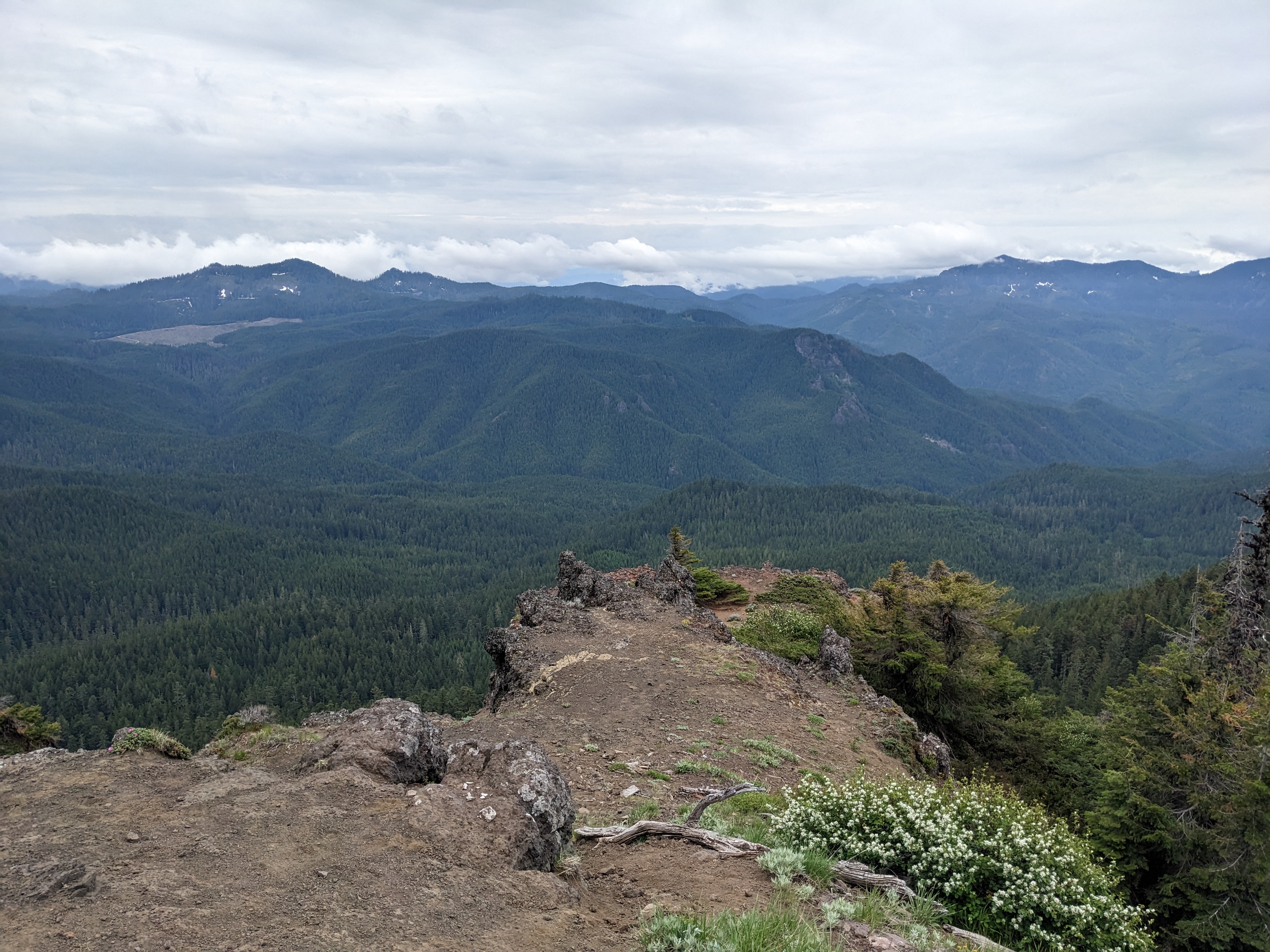
The evening was pretty comfortable and there were no visits from bears or cougars. Instead it was just time to hang out playing cribbage, reading, chilling, and sleeping comfortably. In the morning, it would be time to hike out, but we had both agreed that we wanted to begin the day with a trip up Red Butte. It was right there at our campsite and I imagined the view on top was spectacular. Plus, my watch had an old trail on it, so it gave us something to follow to get to the top. We were up early in the morning and we found the trail pretty easy at first. It was somewhat steep, but nothing scary. At times we would lose it given that it was not officially a trail, but we would find it again later.

There was a bit of snow, but nothing that we could not avoid. It wasn't long before we were topping out and got to enjoy the big sweeping views. Conrad was excited by climbing this pseudo mountain and the top was nicely flattish for views in all directions. We were both happy that we took the extra time to hike up here. We headed back down and were back at camp in no time. Here we packed up the contents and were off on the trail again. Back were the heavy packs and the difficulty of climbing over blowdowns. We were both getting pretty good at getting over these at this point and soon we were back along the shores of Duffy Lake.

This took us back through the forest. We saw the backcountry horseman on their way up clearing trail as they went. They asked us about blowdowns ahead and we told them there were a few. Not sure how far they were going, but we told them that we appreciated their work. From here, it was smooth sailing with the blowdowns all cleaned out. Soon we were back at the trailhead happy to take off the big packs and hide from the mosquitoes for a while. It is amazing that when you are done with a big backpack, you are just as happy to be back as you were to go. There was nothing left to do but enjoy some ice cream sandwiches and drive the short hour drive back home. What a great trip. Conrad had fun, I had fun, and we both had great memories to look back on for a nearly flawless trip.