Friday, December 13, 2013

Alakai Swamp

Today we were heading up the hill to hike the Alakai Swamp trail. This trail was near Waimea Canyon which was this beautiful canyon with reds and greens seen from viewpoints along the road. It was just three of us today, Dad, Paul and I. We drove up this steep road that gained elevation quickly in a series of steep switchbacks. We didn't stop too long to take in the view as we had a goal for the day. When we got to the trailhead, there was still parking left and we got going. The first part of the trail offered amazing views down into the gorge below that led right to the ocean.
This picture was the classic one of Kauai and was truly stunning. The trail itself was in awful shape. There was no effort in this section to improve the trail and it just looked like one giant swath of exposed, slimy dirt. That is one thing that I found unappealing about the Hawaiian islands is that it is this lush paradise, but they don't seem to take any time to improve their trails. We hiked this one for a time, trying to all keep our balance as it went up and down, mostly down until we ran into a trail junction.. The first junction we did alright at, but the second one was a three way junction.
We took the one that said Alakai Swamp because that was the hike that we were doing. It turned out that we were supposed to take the one that went out to the lookout with its own name, Kilohana. I had not read the guidebook close enough to remember that and neither did anyone else, so we ended up coming out at a separate trailhead. Oh well, we sat down to have lunch and then headed back. Luckily the extra portion of trail was the best we had seen on the day and everyone was still in good spirits. We added about 2 miles to our 8 mile hike with this side trip.
The weird thing was trying to explain this to the people we saw hiking back from the lookout. The trail to the lookout was mostly boardwalk and steps. This led through a swamp that was really not a swamp, just some muddy ground. Getting to the lookout was sort of anti-climatic as there was no view. It was socked in by clouds. We also shared it with a couple from Sweden who took the best bench and didn't seem to be in any sort of hurry. We left them after trying to call Jacqueline to tell her we would be a little later than we thought. They were possibly going to meet us, but now with our added time, we were going to miss them for sure. Still, I made sure to make it back to the trailhead by the time that we had told them on the phone. By the end of the hike, we had received a bit of weather and it was rather socked in. We missed Jacqueline and they had missed some of the views as they had clouds near the top. Oh well, it was still nice to put a few miles in and enjoy the lush forests of Kauai. 

Wednesday, December 11, 2013

Shipwreck Beach

Paul showed up in the evening of our first full day. The next day started out with a morning hike along Shipwreck Beach. We didn't really have an itinerary for how far we would go, just that we had to be back in time to go swimming at a kid friendly beach in the afternoon. We first walked with the entire crew to the Grand Hyatt resort where Jacqueline, Laura, and Zyla left us to go enjoy feeding the fish. The rest of us headed over to Shipwreck Beach. We walked the beach for a short time and then hiked up some rocky cliffs to a viewpoint.
We stayed on these rocky cliffs as we hiked along the coastline for a few miles. It was nice to be able to have this somewhat secluded coast line for hiking. Our hike took us past a couple of small beaches with pinnacles of rock right next to them. We ended up hiking over a golf course that seemed like an amazing spot to play some golf. We left the golf course and ran into a strange cave. It was the Makauwahi Cave that is of course sacred to the Hawaiians. We were able to find a way to get into the cave where there was some guy there who was telling the visitors about the cave.
It was kind of a funky place because it looked half manicured, half destroyed with piles of equipment and roped off section of cave. There was a archaeological dig going on where they were finding all sorts of artifacts and old plants. We listened to the guy talk for a while and then went out of the cave across the bridge to where there were a bunch of tortoises eating plants. We then went down to the Gillin Beach to sit down and enjoy the water before heading back.
We made it back a little later than we were expecting but in plenty of time to enjoy the afternoon at the beach. We went to Lydgate Beach where there was a barrier built up to block the waves. This was perfect and Zyla loved playing there while we all took turns snorkeling.

Tuesday, December 10, 2013

Waterfalls on Kauai

Well we had done the worst of it. The long flight to Kauai was over. Dad and Tom got rental cars. We checked into our condo. We visited the beach and then the next day we had to figure out what to do with ourselves. Dad and Laura had a plan to go to the Botanical Gardens, so Zyla, Jacqueline, Tom and I went on a waterfall adventure. If you go to the Garden Island, you might as well appreciate the lushness of the whole thing. The first one we went to was Wailua Falls less than a half an hour from where we were staying. This one was impressive, but also right by the road.
The guide book said that there was a trail down to the base of it. When we looked at it, there were so many signs saying not to go, that we had to not go. We met another couple with their kids from Wisconsin there. We left that spot and went to our next waterfall spot. We were visiting Ho'opi'i Falls. This one was going to take some hiking. Without the GPS, we never would have found the trailhead. It was just a small parking spot in a culdesac. We parked the car and immediately met some out of shape guys who looked like they never hiked. They told us it was going to be hard.
 I also saw a tarantula wasp of some kind dragging a large spider. I was the only one to see it, but it was pretty neat. The trail then descended slightly downhill. We saw a gecko on a plant, but for some reason Zyla was not too impressed. She was more impressed by the horses right nearby and immediately called this her animal farm. She also named the horses. We kept going downhill until we got to the creek. As soon as we got there, Zyla of course had to go potty. We tried to manage it the best we could but it did turn into a big mess.
 Luckily we were prepared parents, but still it was not an ideal situation. We continued on downstream after that. We ran into another couple with kids and talked with them. We ended up high above what looked like some falls. I went down to investigate. Sure enough, this was the right spot. We slowly maneuvered ourselves down to the lookout point where we took in the falls. Then it was back up the trail to go to the lower falls. The trail was very slippery and muddy from here on out. Jacqueline and Zyla had enough when I slipped and took Zyla down with me. I was worried that I had hurt her hand, but she was okay. The three of them stopped for lunch while I ran ahead to see the lower falls. I literally ran, saw it, snapped a picture, and then turned to run back to where they were. Once I was back, it was back up the trail. Everyone had a much easier time going back up the trail. Zyla was a great hiker on this day and we made it back to the trailhead in good time. We figured this should be the end of our waterfall exploring, though, as Zyla and I were muddy enough as is. 

Saturday, December 7, 2013

Pack Forest Trails

Well we were off for the winter furlough. This started with a trip to Arizona to see Aunt Kris and my friend Steve. Then we flew to Washington to see my mom and Carl. Our plan was to leave Conrad with Mom and then fly to Hawaii to meet my Dad and Laura, Uncle Paul, and Grandpa Tom. Before we did that, we had a few days in Washington, so we spent some time visiting with people like my Grandma who had not met Conrad yet. While we had some down time, Jacqueline and I went for a hike out in Pack Forest. Carl had a good map, so we ventured to some trails that we had not hiked previously. When we got to the trailhead we were a little worried about some people in a big van. The weather was extremely cold and they were obviously stealing firewood from the facilities around Pack Forest.
 We made sure to lock our car and Jacqueline even went back to make sure her purse and phone was with us so that they didn't feel the need to break into our car. After that it was down a flat road until we hit another road. This took us to what was called the Wildlife Trail. This took us through some nice forest with decent trails. The weather was so cold that the trails were in pretty good shape because the mud that could obviously be there was completely frozen. Our feet were a little cold but sooner than later the trail put us moving uphill.
 Jacqueline was a little bit worried about our direction of travel. I had a map, though, so I assured her this was the correct direction. The trail went all the way around the sides of Hugo Peak. At some point the trail switched names to the Reservoir Trail. We could tell we were getting close to one of the many roads when we started seeing signs about being a managed forest and telling about the trees. We did hit a road and then took the Advanced Horse Trail back to the car. It was fun being on a hike with just the two of us as it had been a long time since we could do that. It only took a few hours, but in the afternoon in Washington during December, that is all the daylight that we had. The people at the trailhead were gone and the car was left alone. Time to leave the cold for the warm weather of Kauai. 

Tuesday, November 19, 2013

The (Re-)Discovery

I was determined to find "The Skull" on this weekend, but that hadn't help me find it yet. I knew if I had to search every square foot of the east side of the park, I was going to find it. So I picked out a route that I had done before, but not looking for "The Skull". I did not know if there were any hoodoos on this route, but I thought I would give it a thorough look regardless. It ended up being an excellent hike on the east side of the park, but did not yield any skull like formations. This was getting frustrating. I finally resorted to looking at Google Earth.
There were still some areas left that I had not thoroughly explored, but I was not sure if there were any hoodoos with iron concretions at these spots. Google Earth has vastly improved from when I started to use it years ago. I could see for sure, there were some iron concretions in these exact spots. The next day, I was back at it and this time I could smell victory. I did not have to go far, only about 15 minutes from the car before I could look up to see some iron concreted hoodoos rising above me. I went up a steep slope that took a slight bit of route finding to find the safest route.
When I looked at the picture in my hand and looked across from where I was standing, I let out a shout of joy. The peak in the background matched up with the peak in the background in my picture. There were a group of lodge employees hiking below me and I wonder if they heard my exclamations of joy. I continued up a little further and went into a little nook, turned around and there it was "The Skull". It was awesome! This was like finding buried treasure or about as close to it as I think I will ever come.
I took a ridiculous amount of pictures from different angles trying to recreate the photo that was in the picture. The nice part about it also is that it is in a hard enough to reach place that I don't think that people visiting it could destroy the actual skull formation. They could trample down vegetation that looked in pristine condition as I don't think anyone had visited this spot in many years. Feeling overjoyed, I left and went back to the car. I saw the lodge employees but I never told them of my success. You may notice how vague my description is. This is on purpose. I want everyone to experience the joy of finding "The Skull" for themselves. There are few that would put the time and energy necessary, but I will tell you in the end it was very rewarding and worthwhile to discover it for myself. 

Friday, November 15, 2013

The Continued Search for "The Skull"

Well, I had eliminated some areas of the park where "The Skull" could be, so I decided to spend the day on the East side getting a few things done. I started off in Many Pools area where I quickly jumped off the traditional route to go look for "The Skull". This was a really good area with lots of hoodoos. I found some bighorn sheep up there and a ton of hoodoos, but there was no "Skull".I was happy to see the area, though because it was one of the best collections of iron concretions in the park.

I could see down into petroglyph canyon below and see people hiking in there. I turned around and went back into Many Pools. This place was definitely impacted from the amount of people that had been hiking there recently. But there were no major problems, so I moved on to the next spot. On this day, that spot was Canyon Overlook. I knew there was graffiti down near the end of the trail.

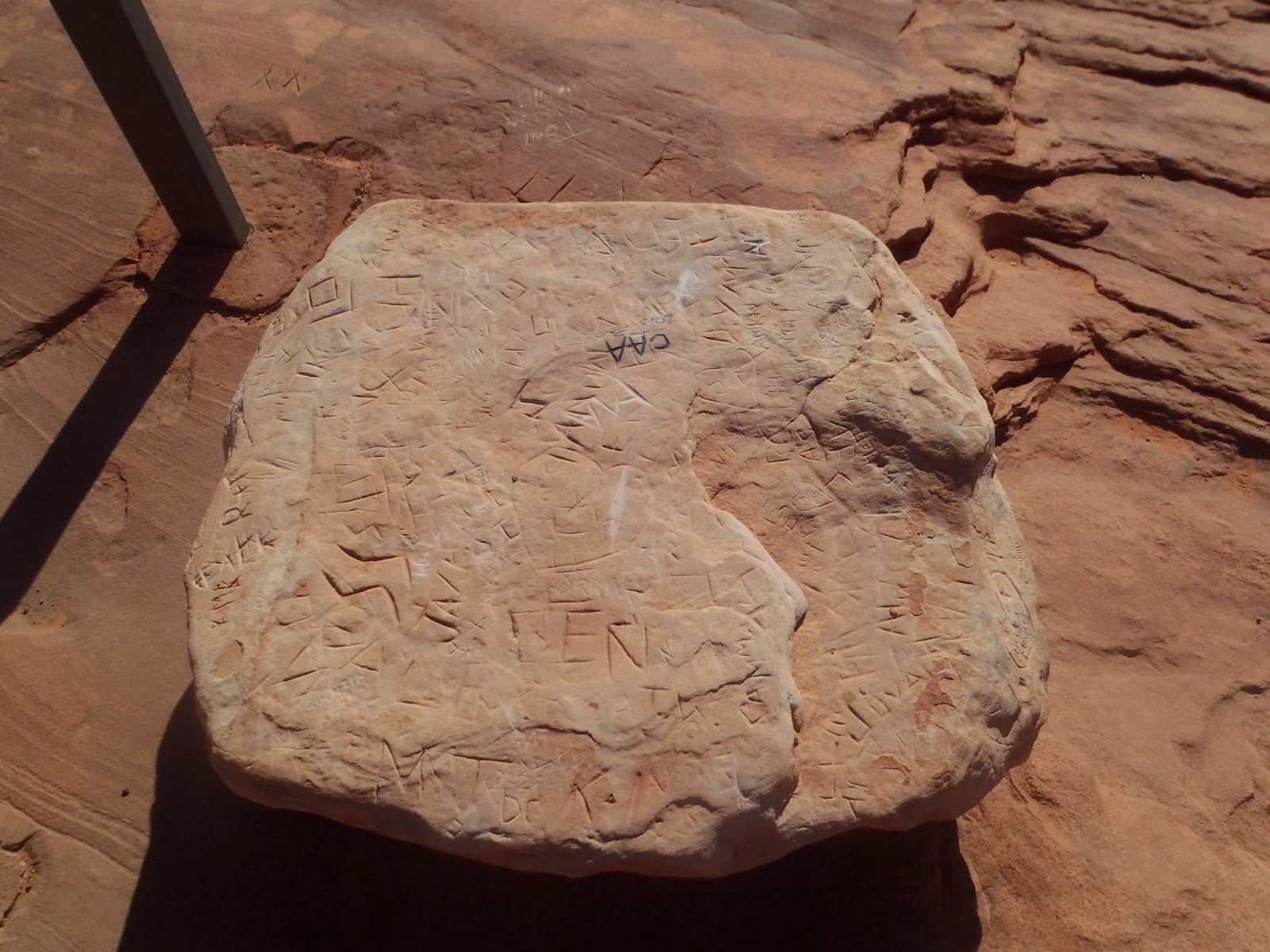
So I brought out the hammer and the brush. I had to completely remove the top of the rock. This is common procedure. I educated the visitors out there and heard the usual from them that it is such a shame. Yet, people continue to do it. I made sure to get a before and after to give to our facebook team.
They ended up putting it on the website and it made it all the way to KSL Salt Lake evening news. The guy pushing over the rock in Goblin Valley was still so fresh that this was something that people were interested in for a short time. Yet we do this so frequently it is ridiculous. The finish of the day was a trip up Shelf Canyon. This produced some garbage to pick up, but mostly just an enjoyable hike. 

Tuesday, November 12, 2013

Nippletop and the Search for "The Skull"

In the Zion Canyon Visitor Center, there is a picture of a rock formation referred to as "The Skull". Many visitors would come in and ask about the location of that formation. No one knows where it is and for many years I did not consider trying to find it.When Derrick and Seth told me about their search, I got inspired. I knew that once I put my mind to it, I would exhaust every possibility until I tracked it down. Some days during work we would quickly go explore some rock formations near the road that could contain "The Skull".
So far we had been shut out. I had a picture of "The Skull" that I printed out. There was only one out there meaning whomever had found it first had not shared information with anybody else. I had determined that forget work time, I was going to go find this on my own time. I started in the location where near the road it seemed to have the most hoodoo formations with iron concretions on the top.
This naturally led me on the path toward Nippletop, a peak that Paul Holthouse and I had attempted to climb the previous December. We did not like the appearance of the steepness of the climb and had instead climbed a lesser peak. This time though, I found a different way to approach the peak, the same way that Paul and I had bailed the previous time.

This kept us from the exposure of coming up and approaching the peak from the ridge route that was very exposed. It still put me on the ridge, but later on the ridge route. It was still exposed, but I just took it slowly and eventually I got to the steep section. From below, it looked nearly vertical. Once I was there, though, it wasn't too bad. It was semi exposed, but picking my way up, I followed a faint trail that led me to the only class 3 move I had to make the whole time. Then it flattened out once I was above the thick Navajo layer. I followed the shallow incline until getting to the summit block. I maneuvered around that until I figured out the right approach and was soon standing on top.
Of course, the view was awesome as it usually is with most east side summits. I enjoyed the top for a time, happy with my accomplishment. I started down and this time I stayed on the ridge to look for "The Skull". My route took me over exposed slickrock, through canyons, and down steep drop-offs with some excellent looking hoodoo formations, but never was I able to track down the infamous "Skull". I put in a full day out there and felt good about the exercise and the peak that I had climbed in the process. I was not done and "The Skull" would have to be found on another day.

Friday, October 18, 2013

Fall Color in the Narrows

Everyone that comes to the wilderness permits desk is often looking for a secret about Zion. When is the best time to do this or that? Well, I will let you in on a little secret. The best time to hike the Zion Narrows is mid-October. Sure, you have to use a wet suit or dry suit and the air temperature is not particularly comfortable, but as far as beauty which is what you want, this is the best time of year. I did not know that, though, until I embarked on this expedition.
 As I got a ride from the EOC to the Temple of Sinawava, most everyone thought I was a bit crazy for going into the Narrows during this time of year. I was the first one up on this particular day. I needed to hike all the way to the park boundary. I was supposed to hike down from the top but I could not get a ride, so up from the bottom I was going. This is a trip we do not let backpackers do because of the fact that more than likely people will just camp before their actual campsite. I was only 1/2 mile up the Narrows when I ran into something I never saw before in Zion. It was a beaver swimming around in a pool in the lower Narrows. Unbelievable! The fact that this guy could live there with the throngs of people going up the river every day was just remarkable.
I was so excited to see him and life in the lower part of the Narrows. My goal with all this was to take pictures of social trails to see how they were rehabilitating. The results were mixed, but I feel like I was moving in the right direction. In the middle of all of this, I was able to enjoy the pretty sights around me also. I was staying in campsite number 6, which was right by the entrance to Kolob Canyon. The river had been a tough fight going upstream and I could see why as there was nearly 30 cfs coming just out of Kolob.
After Kolob, upstream, it was a bit easier going. I hiked all the way to the park boundary checking permits along the way. I ran into a group at Deep Creek late in the afternoon. They asked if they were doing well on time and I had to tell them, no, they were not doing well at all. They had to get moving quickly. I never heard anything from them after this, so I am assuming that they made it out okay. In fact, there were many of the backpacking groups getting in late. I was happy to fill up my day with hiking all the way to the boundary and back to six.
It was a cold evening and morning, but I was happy to see that my wet suit was dry by the A.M. The next day was smooth sailing with the current helping me downstream spending some time working on social trails trying to get them looking good for the season. They were as good as they were going to get. I even put up 5 signs because I spent so much time on the same trails. This was a hard decision as the last thing a person wants to see in the Narrows is a don't walk here sign. But they also don't want to see a large eroded trail either. I was happy to get out and warm up, but also sad that I could not do more as there were some trails that I had not been able to do all I want. I still felt like it was good for a season of work, especially when it is not exactly within my job description. Just want to leave the park a nicer place. 

Saturday, October 12, 2013

Hide and Seek

The park finally re-opened. I went to work for one day for a couple of hours and then had a 3 day weekend. So we had some time on our hands and decided to use it to do a little bit of hiking. So we drove up the KT road and out to the Wildcat Canyon Trailhead. It was a beautiful day and a little bit cool, but comfortable. I was carrying Conrad, Jacqueline was carrying our stuff, and Zyla was carrying herself. This was an ambitious plan as Zyla was going all the way out to the Peaks and back which would be a 4.5 mile roundtrip. She did well for about the first half mile and then seemed to lose interest. We tried bribing her with "bunnies" like we did on the Coalpits hike, but she was less interested.
There is just so much that you can do to convince a 3 year old that continuing to hike was in her best interest. So we tried different motivation and played hide and go seek. I would hide and Zyla would come find me. Then she would run ahead and hide and I would come find her. Then we would both hide together and Mom would have to find us. Then Mom would have to hide, etc... This continued for miles on the trail. Zyla just never got sick of this game.
 It was not a day of enjoying nature and the beauty that surrounded us, no it was a day of hiding in the wilderness. Luckily we really had much of the place to ourselves, so there was no issue with her running around. There was one couple and we actually kept pretty good pace with them. In no time, we were at the end of the trail and taking pictures. We stopped for a bit here to enjoy the view and have a snack, but we were soon on our way hiding and seeking our way back.
Zyla found this enjoyable for the first mile or so and then eventually she got extremely tired. For the last mile, Jacqueline carried her about half the time as she was spent.
Still an excellent day for her moving well and really fast with her parents pretty tired after the hike also having to add a bunch extra by hiding in the woods. Really fun day with some excellent pictures coming out of it. 

Tuesday, October 8, 2013

Mineral Gulch

Well, the government was still under shutdown and while the crazies were coming out in Washington County with talk of taking over the park, I was using my skills of different routes to find a place to go outside the park that I had been interested in seeing. I called up some friends and convinced Patrick that we would have no issue pulling this off. Patrick came with me on a couple on canyoneering trips this year, so I had confidence that he could handle a long trip. So we went to go through Meadow Creek to Mineral Gulch. This had been on my list for quite some time of a trip that I was excited to do.
We left bright and early during the morning and it was strange to drive through Zion. The place was eerily quiet. Despite the reports of kicking people out of places, there just were not any people really to kick out by this point. Meadow Creek was located a few miles outside the park. It met up with Mineral Gulch that led into Parunaweap Canyon. We started hiking from a piece of old road that used to be Highway 9. The beginning of this was just route finding through the trees on a ridge that dropped us into the canyon. From there it was following a weak stream down.
 We did our best to keep our feet dry as we knew this stream was going to dry up. We saw what we believe was a fresh mountain lion kill sitting in the stream as there was still fresh blood floating around the kill. Almost immediately after this we came to the first obstacle. It was a 20 foot rappel down a slopy section of rock. There was already a rope installed, so we just used that. It was an awkward rappel, so I told Patrick to just handline it. He had a simpler time with it than me. Combined with another waterfall that we could walk around, these were the only obstacles and the rest of the canyon was mostly easy going. 
There was an unimpressive arch a few miles in. Patrick expressed his displeasure with arches and I would definitely have to agree with this one. Downstream we ran into the confluence of Mineral Gulch and continued down that. We heard a voice and far up above us was a man on a four wheeler, so far we could barely make him out. We kept going farther downstream and eventually the views were fantastic. The canyon became super narrow but still incredibly flat. This was an amazing canyon that would be a photographer's dream. It opened up a little bit and we found a cave with some pictographs in it. These were made with yellow paint. There were also cow pies and fire scars from many campfires in there. Still an awesome sight to see, but it could have been made better if it was protected a little bit better.
 We went down some more amazing narrows until it opened out to Parunaweap canyon. Patrick was hoping to get into the barracks, but unfortunately that was quite a ways downstream from us. We would visit that during a separate trip through Fat Man's Misery later that month. On this day, we just turned around to head back upstream. It was back through all the pretty narrows until we got to the junction with Meadow Creek again. Instead of heading back up Meadow Creek, we went over to Seven Canyon instead, so named because there was an arch that looked like the number 7 in it.
 There were all so some petroglyphs and that was our main goal. These were pretty incredible, though faded. There were a lot of them, mostly bighorn sheep. We saw some bighorn sheep on the hike high on the cliffs above and you could really tell that people hunted them and it was a blessing to be able to bring one down for meat. We decided that seeing the glyphs was good enough and the arch would have to wait for another day or never to be seen at all. We went back to Meadow Creek and started to head up that one. The one drawback of this hike was the large amount of time one had to spend in mostly wide open canyon.
 Still, the cliffs were scenic and the hike back seemed to take less time than it took coming down. We hiked up to the base of the waterfall this time and while there was not much water it was still quite a drop. We made it out a little after 4 p.m. making it about a nine hour day to do about 20 miles. It was definitely worth it to see the beauty of that place and definitely not as challenging as I thought it might be. It would have been very hot midsummer so this was the perfect time of year to do it. Patrick was nervous about the length of the trip but never once did we have an issue as we moved well the entire trip.

Monday, October 7, 2013

Shutdown Hike

My mom had come out to visit to take care of the kids while we worked. Unfortunately, the government decided to shut down corresponding with her visit. This meant less time for her with just the kids and more time for her to see Jacqueline and I. One irritating thing about Zion being closed down was that not even I could go into the park. So that meant all the hiking in the park was off limits to us also even though we were park rangers. I needed to get out though because it was pretty irritating to have to sit at home and check CNN to find out what was going on.
So, mom and I went out to Eagle's Crags. I was expecting it to be busy up there because of the park being closed, so we got an early start. This was a good plan because there was no one at the trailhead when we started. The hike was good and predictable. Mom hiked well and we made it all the way to what I considered the end of the trail. Going down we started running into a lot of people who were hiking up. I even had to give some of my water to a couple that was concerned about running out of water.
 There were quite a few people on the trail who definitely would not have hiked this trail had the park been open. I considered that a positive because it broadened people's perspective about the area and what it had to offer. When we arrived back at the trailhead, it was sure busy. There were cars parked all over the place. I was glad that we got out and that I got to spend a little bit of quality time with my mom. 

Monday, September 23, 2013

The Kids in Coalpits

Grandpa Tom was up for a visit and Jacqueline had to work. So he and I took the kids out to the Coal Pits Wash area. I wanted to see what Zyla could do on a mostly flat trail. She has never been a very ambitious hiker as there are just so many different things to enjoy and really what is the purpose of going farther anyway. She is seeing new scenery everywhere. I took a risk by only taking the one baby backpack for Conrad. She started out great and even wore her backpack. We were moving along quite well for the first 1/2 mile. Then she got semi-distracted and disinterested.
 That is when I pulled out my secret weapon, some bunny crackers. I kept these in my pocket and Conrad and I led the way. Grandpa was behind her making sure she did not get too far behind. When she would get hungry for bunny crackers, she would suddenly spring ahead and come get one bunny cracker from me out of my pocket. Then it was back to just moseying along until another round of bunny crackers. This kept us moving along. We nearly made it to campsite #6, but at that point we finally got some shade from some rocks near us and decided to pull out Conrad and get a larger snack then bunny crackers. At this point we were a mile and a half in and just hopeful that Zyla could continue it for the next mile and a half back. She did fantastic on the way back. She really got excited about the hills. There really are not many out in the Coalpits area, but Zyla really enjoyed them.
 They were only there when the trail crossed a wash. On the way down, she would hold one of our hands, but on the way up she would want to do it herself. So here was my little girl in a dress scrambling up these steep little hills. It was so cute and it made her daddy pretty proud. We seemed to make good progress all the way back and by lunch time we were out and back to the trailhead. I felt like we had maxed out what Zyla was capable of doing on her own and now it was back home for the afternoon nap.