It was now time to enjoy our winter. Jacqueline and I hadn't taken a real vacation together since we went to Tasmania on our honeymoon. We were wanting something tropical with beaches and mountains once again. We chose Hawaii and specifically the island of Maui. We wanted to spend time with our family on this break also, though, so we got ourselves a condo on the island and invited our friends and family. Luckily, a lot of them wanted to join us. My dad Roger and his wife Laura flew out with us from Washington State where we were visiting for the month of December.

Jacqueline's dad Tom flew out from Michigan and met us on the island. And we were waiting the arrival of Jacqueline's brother Paul in the evening. We had spent the first day doing all the necessary parts of flying, rental cars, groceries, condo check-in, and room assignments. We were now ready to enjoy ourselves. We spent some time at the beach in the morning, then it was off to do what we do best and go for a hike. The island of Maui has a lot to offer as far as hiking destinations. We chose to go up to the Northwest corner and do a hike called the Swinging Bridges. The problem was that when we got to the trailhead, there were no trespassing signs saying that this was now a closed area.

So we went with a back-up plan and did the Waihe'e Ridge trail, though, it wasn't the most popular idea because it gained a lot of elevation. We needed to get out and do something fun, though, and this was in the neighborhood. The trail started out paved and steep. We saw a few other people coming down, but not many going up. We entered a really interesting forest with crazy curved Dr. Seuss like trees. These trees are Norfolk pines and strawberry guava. The trail continued to climb and our group shrunk from 5 to 4. The skies were overcast, but not particularly rainy. The clouds just seemed to sit over these green mountain tops and we could tell that we were climbing into those clouds. Eventually, our trail popped out of the forested area and out to a very prominent view.

Thank goodness that Hawaii had all this lush greenery that made it very difficult to just hack your way through, because on an island with so many visitors, it sure seemed like we were looking at some rather pristine views. We were lucky to have views of both the lush green valley and the ocean with all the resort hotels along the beach. We continued on up the steep trail that was now more open and thus became more slippery. As we were only about 45 minutes into the hike, our group now decreased down to 3, but Jacqueline, Tom, and I continued on.

We were able to continue to soak in the views of the Waihe'e Valley and the coast beyond for some time, but soon the slippery trail climbed steadily up into the clouds. We thought that the views would get better on the top when we were starting the hike, but now that we were here, we realized that those views were not going to be better than what we had already witnessed. So about an hour into the hike, and the visibility down to nearly nothing, we decided to turn around and call this hike complete.

Besides, the end was supposedly a bench, so that was not much motivation to continue up the slippery trail. Instead we now had to continue down the slippery trail. I think each of us nearly ate it a couple of times. There were quite a few flowers and plants to enjoy which Jacqueline did her utmost to snap some pictures of. We made it back to the car rather quickly, though, because we were going down all of the steepness that we had climbed up.

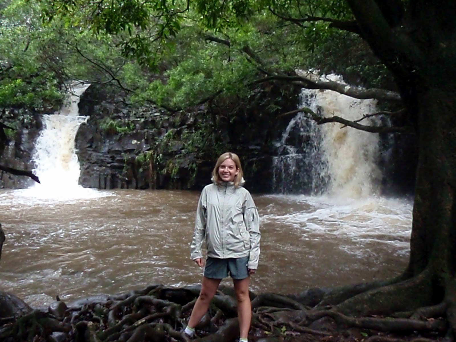
We were not done hiking for the day, or so we thought. Makamakaole Falls were nearby and it looked like it could be the highlight of the trip. We had a guidebook and tried to follow some directions, but unfortunately we did not do a very good job of it. We ended up wandering around rather randomly through the forest on an extremely steep trail without any success. We followed this trail and it shot us out somewhere near where we had parked without witnessing any falls.
We looked closer at our guide book and realized that instead of going up, we were supposed to go down. We looked at that option and knew that our group was not up for it as we wanted to enjoy Hawaii instead of spending our time at the emergency room. The trail was very steep with exposed roots being the main thing to hold onto. It was also rather dirty with lots of trash around. We decided against it and instead went around on the road to see, sure enough, there were some rather impressive waterfalls. I think if it would have been just Jacqueline and I, this would have been a good option because it looked like a rather romantic place to go swimming together.

But we were also fine because it looked rather treacherous to get there and having our family along gave us a good excuse to not have to try to get down there. Plus, we got to share it with other people we loved. We wished Zyla could have been there too, as she had stayed back in Washington state with my mom, but I think we both appreciated the fact that not having her there was allowing us to do some things that we hadn't been allowed to do together for some time. Well, we got back in the jeep, yes we had rented a jeep, and went back to the touristy areas.
We were able to enjoy some good food, an evening walk on the beach, and a beautiful sunset view to complete the day. The great part about being in Hawaii is that the next day, it would be time to get up and do the same thing again the very next day.
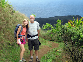
 We had one more day left and Dad wanted to visit the island of Lana'i. It was going to be an expensive ferry trip across and not everyone was sure about going over there, but in the end, we decided it was a grand idea and everybody came along. Dad did a great job of arranging transportation for us from the ferry into town. He and Laura were excited about walking around town and having a little bit of a date day to themselves. Jacqueline and I took Dad's recommendation about visiting one of the highest points on the island and started out on a little hike of our own. We had to walk all the way through town and out to a fancy resort. At the resort, we asked the valet for a map and he gave us one for the hiking trail that led us out from there. We walked through the fancy hotel with many displays, through the manicured gardens, and on the paved path that went around the golf course.
 Finally, it took us to where we were away from civilization a bit and the trail got very quiet. There were a few people wandering down the trail, but it was rather quiet. It first led us through a forest with tall skinny trees, but a nice clear path. It helped that we had a map with numbers on it, sort of a nature trail. This path led us to a road that switchbacked uphill. We followed the road for quite some time. There were many flowers and plants around, but this part of the island was definitely much more barren than the island of Maui that we had been staying on. Eventually the switchbacks gave way to a much flatter trail. This was starting to lead us out to a point. This island of Lana'i used to be used entirely by the Dole corporation to grow pineapples. Eventually, it became cheaper to grow pineapples in the Phillipines, so that was abandoned. Most of the island still remains privately owned, but it has returned to somewhat of its natural state. This natural state, though, is rather dry especially on the part of the island that we were looking out from.
 As we made it to our overlook, we could appreciate the island's differences from Maui. Still green and lush compared to Utah standards, we could still see the ocean amongst the browns rather than the greens. It was a beautiful spot overlooking this big canyon. One thing that we had thought about doing was driving to the actual high point of the island, but had decided that we did not have enough time to complete the long dirt road that would take us there.
 Instead, we settled for the Koloiki Trail that turned out to be a rather enjoyable hike. It left us enough time to walk all the way back down to the resort, back through town again, and to a restaurant to have lunch and still have enough time to meet our ride. He drove us down to the beach where we got some snorkeling and chilling on the beach in. We had to make sure and enjoy it because this was our last day of getting to do all that. It is funny how you just sort of get used to waking up and going snorkeling or sitting on the beach. This section of beach had a few extra waves.
 Jacqueline even got to take a tumble as the waves pushed her around a little bit. Dad, once again went way out and found the coolest fish. He even brought Jacqueline out with him, but I was a bit wimpier and preferred to float closer to the mainland. After a while, it was time to go, so the six of us went back down the road and caught the ferry home. It turned out to be a very enjoyable day for the six of us. We would return to the state of Washington the next day to Christmas and then a trip halfway across the world to Patagonia.