Saturday, October 12, 2019

Top Down Narrows in October

Whose bright idea was it to hike the Narrows in October? Ok, it was probably mine, but the idea was put in my head after spending the afternoon over at our friends Josh and Kara's house a month previously. We met them last year when we discovered that we had both moved recently from Oregon and enjoyed being in the outdoors. I had fond memories of hiking the Narrows in October from my days working at Zion and when I was living in Oregon, the only time that I actually missed hiking it was during October. The colors are fantastic and the weather is typically warm enough to make it enjoyable.
Unfortunately the days we chose to do this hike fell on a cold snap that swept through most of the west. Down in Washington City where we live, it just caused a drop in temperatures, but was still comfortable. Up at the headwaters to the Narrows, though, it was a different story. To get to the headwaters, we had to put in the not so fun part of getting a permit by entering the last minute drawing, obtaining a ride from Zion Adventure Company, leaving home at 5 AM, riding in a shuttle with a bunch of other hikers, and then being dropped off at the trailhead. We could immediately tell that this was going to be rough at first. The temperatures at the trailhead were somewhere in the teens.
I knew that we could get a small advantage on the day if we could keep our feet dry at the first river crossing. There were no more crossings for a couple of miles after that. Unfortunately, all the rocks that we could use to cross the river were frozen. Josh tried to cross one of those and slipped in so now, not only were his feet wet, but part of his arm and gear. I tried to find a place farther downstream, but eventually just gave up and went right through. In retrospect, I should have taken off my shoes and neoprene booties to keep my feet dry, but instead I went for it. It was bone chilling cold and now I had two cold feet to continue the walk down the road.
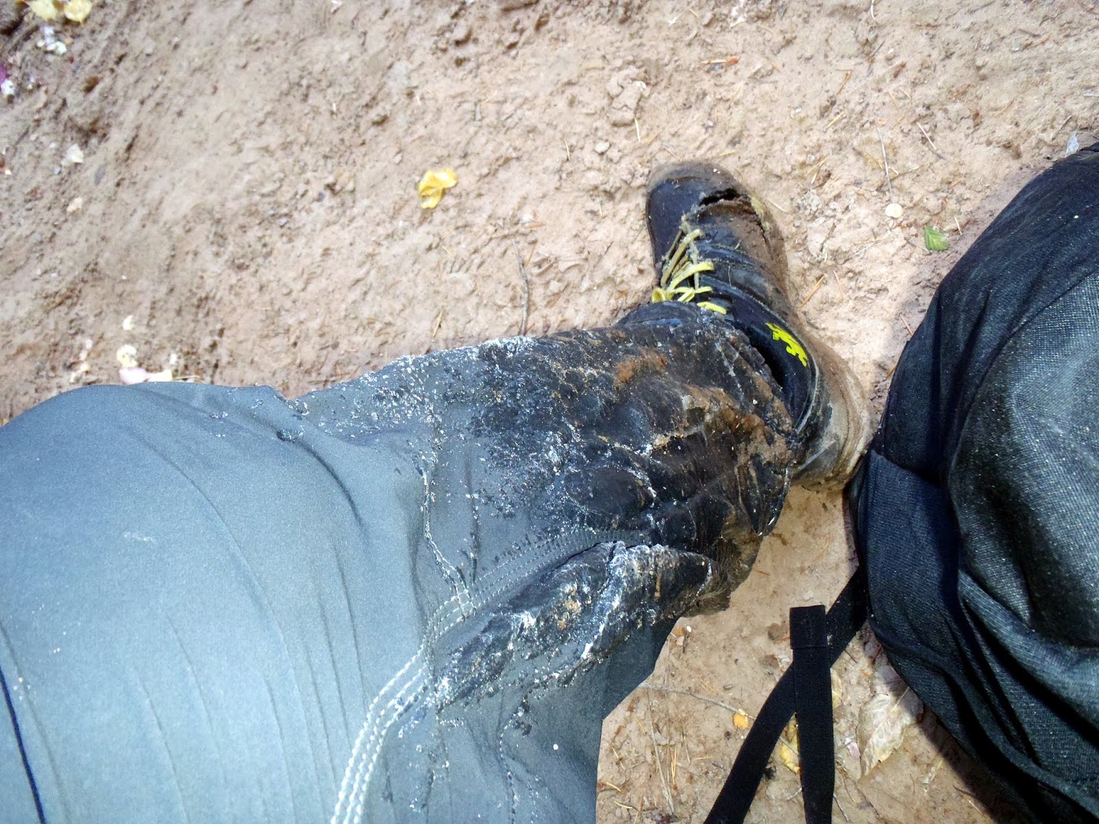
So far, though, it wasn't so bad. We could make good time walking down the road and were even able to pass a couple of hikers that were still on the other side of the river going slow, but with dry feet. I figured the wet feet thing was inevitable, but it would have been much better to not have wet feet during this first few miles. We continued along on our way and eventually the road gave way to the river. At this point, we began crisscrossing the river many times. At first it wasn't so bad, but after a while the ankle deep water seemed like a punishment that I did not want to endure. Josh had much thicker neoprene booties, so his feet were great. Mine, though, eventually felt like two blocks of ice attached to my legs. The sad thing was, that they were well could have been given the fact that my pant legs were looking like the formation of ice on the side of waterfall in winter. It was crazy that every time our legs went into the water and came back out, the air temperature would immediately freeze the water on our legs. Josh, who was tougher than me, was wearing shorts and had ice accumulating on his bare legs.
Given the pain that I was forcing myself to endure, it was harder than normal to look around and appreciate the beautiful colors. The trees were changing and there were many times where the reds and yellows rose up from the river. What was in shorter supply at this point was sunshine. It was not until 10:15, two and a half hours into the hike that the sun finally reached us. We took a break here, but not long enough for my feet to stop being numb. It made the walking tough to not really be able to feel anything when I placed my feet down. Every crossing was painful and I didn't realize how many times I actually had to cross the river.
I would even be that guy who blazes a new social trail just to avoid the inevitable of placing my feet in the river one more time because the longer I kept them out, the more feeling that would return to my feet. I felt like a bad friend because my mind at this time was completely wrapped up in what was going on with my feet. Still, this was an awesome experience and the upper part of the Narrows was great. Eventually we were passing all the landmarks including a new one that I did not understand. Someone had a for sale sign up about a mile from the park boundary. It said that you could own a piece of the Narrows. Wow, that was depressing. I hope some selfish idiot would not buy that from this other selfish idiot.
After we went through the narrowest section, we finally popped out at Deep Creek and headed downstream. I was a bit relieved when I tested the waters because it was much warmer coming from Deep Creek than it was from the North Fork. Given that Deep Creek provides 2/3 of the water for the Narrows, this made the water significantly more tolerable. I am not sure what the water temperature was in the North Fork above Deep Creek, but it was definitely in the 30s. We found a patch of sun right after Deep Creek where we had lunch and I sat in the sun until feeling returned to all of my toes. I was actually pretty nervous at this time, so when every toe was working again at this point, I was happy.
I could now be a better friend and actually have a decent conversation with Josh. The river was swifter and deeper at this point, but much warmer. Never again did my feet go numb, but given that they were numb for over 3 hours, I was still a bit nervous about long term damage. The rest of me felt good as we had not gotten in over our knees at this point and slowly my pants began to unfreeze. We passed by and through many of the campsites and side canyons. I got to relive a few of my past adventures with Josh. He was generally excited about much of Zion and I enjoyed sharing some of my knowledge of the place while also not trying to seem like a know it all. The best experiences are always the ones that we make ourselves anyway, so I just wanted to encourage him to go out and see many of these amazing places also. As we got further down the campsites, eventually we got to a place that opened up between sites 10 and 11 where the sun was out and we were actually warm. I finally shed some layers taking off my winter coat for the first time all day and was able to take off the tights and long pants for shorts.
The warmth did not last an extended amount of time, though, and soon we were in the deeper water. After site 11, the sun disappeared and the deeper water began. It was like a switch was turned off and the sixty plus degree sunny day that we were enjoying was quickly thrown back into a world of winter. The Narrows is funny because unlike much of the rest of Utah, it is free from sunshine for so much of the year that it is definitely a different climate from the rest of Utah at the same elevation. We were surprised to see at campsite 12 that a fairly recent rockfall had occurred. I would not have wanted to be camping in that site when that much debris came down.
After site 12, the canyon immediately seemed deeper, darker, and busier. We saw our first people since early in the morning right around Big Springs. From there on out we were rarely, if ever alone. It was not as busy as a summer's day, but as busy as a summer's day 10 years earlier. The outfitters in Springdale must just be swimming in the profits because everyone seemed to have the dry pants, shoes, and sticks. They all seemed wiser than us as many times were were having to wade up to our waist in water. The thought of doing this earlier in the day would have seemed like misery, but with the warmer air temperature downstream, it was a minor inconvenience. I was cold, but not dangerously so at this point in the day.
I spent the rest of the day going back in forth between enjoying the beautiful canyon and dodging the masses of humanity. Getting below Orderville, at that point it became less enjoyable. Unfortunately this is one of the most amazing parts of the canyon, but it is almost ignored given the fact that there are so many people there distracting your mind away from the beauty. Also, the impacts of people are so bad in there that it made most of the time and effort I spent protecting that place look like a waste of time. I am not sure what the park's plan is going forward, but idly sitting by and letting the Narrows get trampled to death is not a plan. There needs to be something done about allowing everyone to just pummel that place from the bottom up.
This was one of the reasons that I had to leave the park service because I did actually care too much to just let it go when it was impossible for one person to save that place. On our hike out, I saw two dogs on the trail and many people just sitting there hand feeding squirrels. It unfortunately got me thinking of my children who would never know these places without either massive crowds or very restrictive rules. On a day like today, though, I could think back to the quiet and outstanding natural features that I got to experience with Josh in the upper part of the river with just the price to pay of having numb feet for a few hours. Well worth it and when I look back I will always remember the tranquility over the pain especially since it looks like there won't be any long term damage from my frozen limbs. 

Sunday, August 18, 2019

Reconnecting with Zion Canyon

Zion Canyon and I have had a long back and forth relationship. I came to Zion in 2006 to start a volunteer gig with the backcountry division in the park which would then transition into a paid fees position while taking a break from my studies to become a teacher. I happened to meet my wife there which further derailed me another 3 years working for what would become the Wilderness division.  We would marry in 2008, but with both of us working seasonally, we finally made the transition to teaching. Two years later with the addition of a child, we were back. She was still seasonal, but I was a term employee with benefits. Enough so, with that we were able to afford another child and day care expenses. 
But just barely and for another four-ish years we made it work, but with my approaching term ending with 2 children to raise, we made the wise decision to go back into teaching. We moved away to the McKenzie River in Oregon, which was both fantastic and challenging at the same time. We stayed in Oregon for 3 years, but eventually we found ourselves back in Southern Utah, teaching this time. This is where we find ourselves now in our third year teaching in St. George. While I would have loved to work for Zion National Park again, there is a part of me that is glad that I do not. It also helps that it is near impossible to get hired back at this point due to rules changing while I was away, but still I do feel that now I am truly seeing Zion from an outsider's perspective. 
But I still love it and I mean who wouldn't. The big issue for me, though, is everyone else seems too also. Or do they? Is it just another box to check off? Is it something to say that they did? I am not sure because experiences vary. For some people a morning hike up Angel's Landing and an afternoon in the Narrows is just perfect. From the lines and crowds, it seems like this is ideal. For me, I wanted to know why this place was protected and what the early visitors to Zion were experiencing. So I have been reading a massive amount of texts from when it became a park and before. For me this is great reading because it gets to the bottom of why this place is here for future generations, but also why it is so insanely overcrowded. 
So, many of the earliest experiences were men on horseback riding up the main canyon along the river to the beginning of the Narrows and back. This meant most of their travelling was in the Virgin River which made it dawn on me that I had never hiked the river from the Temple of Sinawava down. So I got inspired and on a Sunday in August, I did this very thing. I wondered what it would be like given that I avoided the main canyon like a plague because of the parking issues, shuttle riding, and massive amount of clueless, sunscreen smelling, and unfamiliar faces I would encounter along the way. 
It was incredible and let me tell you why. It was just me doing this hike on this day and it felt wild. Strangely enough, I could be near people, but my experience was much different then what they were having so I was not in their world. There was no trail because I didn't need one. The river was there to guide me down the canyon and this river ecosystem felt much wilder than a few miles upstream where it was getting pounded in the Narrows. This turned out to be a really good idea that allowed me to reconnect with the main canyon for the first time in years.
My hike actually started in Pine Creek because the parking was so tough that I had to park quite far away at the first turn out. This gave me a chance to see the Pine Creek bridge which is truly a feat in discreet engineering. Each rock was taken from a different part of the park to make this truly a rainbow bridge. This was the last piece of the tunnel road completed in the late 1920's to open the road from Zion to Bryce. I tried hiking down Pine Creek, but there was so much vegetation that it was a battle. Eventually I made it back to the road and caught the shuttle at Canyon Junction. 
Taking the shuttle up Zion Canyon is not an experience, but a necessary evil. I stood until the Zion Lodge, packed in tight, but eventually was able to get a seat. When they dropped me off at the Temple of Sinawava, I took a quick trip to the bathroom, then off to the river. I started across from Telephone Canyon and immediately felt like I was in a unique position. When I came back to the Temple, I was in the river. The Pulpit looked different then before and I felt disconnected from the world where the shuttle was travelling. It was just me and the river. I got out of the river right away though because it is actually really easy walking. Zion Canyon used to be a massive lake, so it is actually rather flat, though abundant in non-native cheat grass. I even found myself some sort of sticky plant that stuck to my legs. I did my part in spreading that seed for sure. Almost immediately I ran into a buck and I would see wildlife all day long that was at least slightly nervous in my presence. The coolest thing was the Great Blue Herons that were fishing and flying away when they saw me. 
The best thing about the whole day was seeing that for the most part, the shuttle was doing its job. To be in, what was, the original route to visit Zion Canyon and have it feel nearly wild was incredible. I walked by the Angel's Landing viewpoint at Big Bend and I was not bothered by people or buses. I had incredible views of these monuments and many of my pictures echoed those of the early writers, artists, lecturers, and politicians. This is how they saw the Canyon and why it was protected. This section, at least, was still in its original condition given that the roads, trails, and instagram followers had not made their way down here. 
There were times I saw people like when I came around the corner from the Organ and Angel's Landing to see the bathers near the Grotto after their hike up Angel's Landing. But they were there and then they were gone. It still felt like the original Zion Canyon until near the lodge where extensive leveling and channeling of the river had been done to make sure the lodge did not experience the frequent floods that plagued the early pioneers that farmed near here. I tried to picture hogs running wild in Zion Canyon, which made me think that much of the vegetation was probably in better shape now then it was 100 years ago. 
Still, I could not believe just how quiet it was passing between the Grotto and the Lodge. This is a main thoroughfare for people going to the Emerald Pools. Yet, we were both sort of curiosities to each other as I passed under the stream of traffic on the black bridge leading from the Lodge to the Lower Emerald Pools. Below the lodge it was nearly abandoned, but no less spectacular. There were two women I saw lounging in a hammock, but that was it. Yet the scenes before my eyes were wonderful with the Sentinel dominating, but also the awesome views of Mt. Majestic which is best seen from the Virgin River. 
These are places where many early visitors looked up and said this should be protected or other's should know about this place or this is the house of God. That is what Frederick Vining Fisher thought as he sporadically named everything he could see with Claude Hirschi in 1916. The funny thing is that he named all these different courts along the way, like the Court of Music and the Court of Poets, but the only one that stuck was the Court of the Patriarchs. I am still not sure why some of his words were taken like gospel and others were completely ignored, but it probably comes down to politics that I will not understand 100 years later.
The river continued to flow along nice and meandering like. It was easy to see why geologists are convinced that this was a lake bottom for many years. It was even easier to see after finding my way to the Sentinel slide area. Unfortunately, there is a diversion dam right near Birch Creek that seems to serve no purpose nowadays, but probably has some, right? Below that the canyon became much more sporty. This is because the Sentinel slide is what dammed up Zion Canyon and then river has to make up for lost time to meet the meandering stream it becomes once again below the park entrance. 
Because of this ancient lake bed, it is easy to see why Zion Canyon is so remarkable. Given how flat it is with so many amazing peaks rising above, one can see much of the grandeur for miles before they are there. There is not too much hidden in Zion Canyon so one gets to experience much of it the entire time. Below the diversion dam, though, it becomes a different world of feeling semi-trapped in a narrows plunging river canyon that obviously wasn't meant to be tread by man. It was picking and choosing routes and crossings in the main part. Here I saw the only other people actually hiking in the river as they picked their way upstream. 
I was able to walk right by the slide area and see that it is still actively eroding and the river is still cutting its way through this massive debris pile that has plunged down from the cliffs above. The best part of this section, though, was following the Great Blue Heron as it moved downstream and eventually flying high above to get back to its home. Not a bad place to live. This section was long and challenging. It was the only section of the river that I would not choose to hike again as it was hard to see anything but the canyon itself and the road cut high above until I was nearing Canyon Junction. Here I could look back upstream to see the Twin Brothers and Mountain of the Sun. Eventually I made it back to the shuttle stop where I proceeded up the road back to my car instead of taking the shuttle. It would have been very anti-climactic to end the day like a sardine in the shuttle.
Instead, I was able to reflect on the experience I had and realize that after 13 years of hiking in and around Zion, I had done it. Not only had I enjoyed the main canyon, but I had found a new hike to do that was away from the crowds and allowed me to see the amazing beauty of this place. It gave me hope for the future of Zion because not every place is over run with people checking their cellphones every five minutes or blasting their speakers as they hike. You can still go to the main canyon and find what this place was set up to protect. On this day, it truly did feel like a sanctuary and I was able to have my own original Zion experience. 


Thursday, August 1, 2019

Magic Grove

Tim came in the week before for the night and let me know that he had 3 consecutive days off. This was good news because that corresponded with the last week of my summer vacation. Jacqueline had a few things planned, so we had to work around a hair appointment, soccer practice, and Tuacahn tickets, but in the end we found a way to make it work. We were going to go hike Beartrap Canyon in the Kolob section of Zion. We checked the weather as the week went along and it was not good. There was a big storm predicted right in the middle of our trip and eventually decided that we were going to have to come up with an alternative plan. Tim showed up at my house on Tuesday and we decided that we would leave bright and early in the morning to drive 3 hours to Great Basin. There we would be able to camp at Baker Lake, hike to the Magic Grove which is the largest group of Bristlecone Pines in the park, and climb Baker Peak, one of the tallest peaks in Nevada. 
We got up at 6 in the morning and were gone before 7. Already on the drive, we could see the storm cloud building. Still we stayed positive as we headed toward the blue skies of Nevada. When we got to the Visitor Center in Baker and got our recommended backcountry permit all looked great. As we hiked up the 5.4 miles and 2600 feet of elevation, it was perfect. The weather was ideal and the trail went through many different environments. It was a tough haul, but the trail crew had recently been working on the trail, so it was in good shape. We made it to the lake before noon and set up camp. 
We ate a quick bite and then were off to the Magic Grove. It seemed as if as soon as we really got moving, that is when the storm clouds started to roll in. We crossed the open meadow where there was still some snow and standing water to start heading up the steep slope to get on the ridge. As we climbed the ridge, the wind picked up and soon enough the rain began to fall. We were thinking optimistically, but eventually it started to come down hard. We decided to duck behind some scrubby trees and see if we could wait it out. After 5-10 minutes of that, then the thunder started. We quickly decided to get back to camp. We were almost a mile away at this point, so it was a long 15 minutes of fighting through the heavy rain which quickly turned to sleet as we were above 10,000 feet around Baker Lake. 
Luckily, we both brought separate tents and were able to dive in those. I just sat there for 20 minutes as the heavy rain poured down and the lightning crashed around us. Eventually, I got the desire to get out of my wet clothes and the excess clothing I had brought, now became a necessity. I was drenched and there was a standing pool of water in the tent from how much water was just dripping off of me. It was about 2 pm when I got into the tent where I filled the time reading the book I had brought and listening to the multiple rockfalls until 5 pm. After 3 hours, we were able to get out of the tents and make some dinner. Luckily, we cooked it quickly because the rain came back and we spent another hour in the tents eating and waiting for the rain to stop. Finally it did for good, but the day was kind of shot. I looked up at the slopes of Baker Peak and knew that I could make it to the top of the mountain. Unfortunately, it would have to wait for another day. Instead I took a trip around Baker Lake to get a picture of Pyramid Peak, the place that I had proposed to Jacqueline 12 years earlier. 
We decided that an early start was a good idea considering we had to drive all the way back and Tim had another couple hours after that. I didn't get great sleep, but was able to awake at 6 am Utah time which was 5 am in Nevada. I woke Tim up as the first rays of sunshine came down. It was a beautiful clear sky. We ate breakfast and then headed up to the same saddle that we were going to yesterday when the skies opened up. This time, the going was a little easier, though my shoes were still soaking wet. Along the way we saw a couple deer and a herd of bighorn sheep on the slopes of Pyramid Peak. 
We made the saddle and surveyed the route. It looked like we just followed the ridge, but the ridge looked a bit steep. We proceeded cautiously, but were always able to find a way up. We stayed on the west side of the ridge because the east still had a sketchy snow and ice pack. The first two peaks were the hardest scramble and soon we were looking across to Mt. Washington and realizing that the hardest part was behind us. It was now smooth sailing down to the Magic Grove that we could see clinging to the flanks of Mt. Washington. 
The ridge hike was one of the more remarkable aspects of this trip as the views down into Johnson Lake and the surrounding Great Basin region were fantastic. It is not very often where you can travel at 11,000 feet plus and soak in the amazing views. The ridge proceeded downward to the Magic Grove. It was not long before we were there and it was incredibly large. There were signs at both ends which is strange to see, but we would have known we were there regardless. The grove covered this entire ridge and sloped down into the valley below. 
Tim was our official photographer given that my camera had finally seen the end of days. It had survived for 11 years including a 5 month vacation in the Narrows over winter. The lcd screen finally cracked and I will be now forced to find a new camera. He did a great job of taking pictures as the Bristlecones are just a gnarly tree. We walked the entire ridge soaking in the many shapes and varieties that these trees came in. This is a great spot because, though not insanely challenging to get to, it is still far enough out of the way that most people are not going to put in the effort required to get there. Well it was time to start heading back. We considered climbing Mt. Washington the previous day, but that was not going to happen with our limited time. We journeyed back over the ridge which literally felt like we were going uphill both ways. It is challenging when the downhill portion of the hike has to be somewhat careful and choosy because we are picking the best spots to put our feet. I really enjoyed the ridge, though, and wouldn't mind coming back there in the future. Great Basin never disappoints. 
We were able to make it back to our camp at Baker Lake and get packed up quickly. In the process of pulling all my clothes off the tree that became my drying rack, I somehow forgot my hat. Unfortunately, it will be a donation to the next lucky person that makes their way to Baker Lake. The trail was down, down, down to the car in which we went from the alpine, to sub-alpine, to the pinion juniper, to the manzanita, and lastly into the sagebrush. All the while, we enjoyed the green grass and flowers that grew along the creeks. We were off the trail before noon and able to begin the long, hot drive back to the desert. It is nice to know that these wonderful, peaceful mountains will still be there when we return in the future.